I had a great ride this week…a loop through the Santa Cruz Mountains down to the Pacific coast and back. Think giant redwoods, beautiful scenes, great roads, and a rich history.
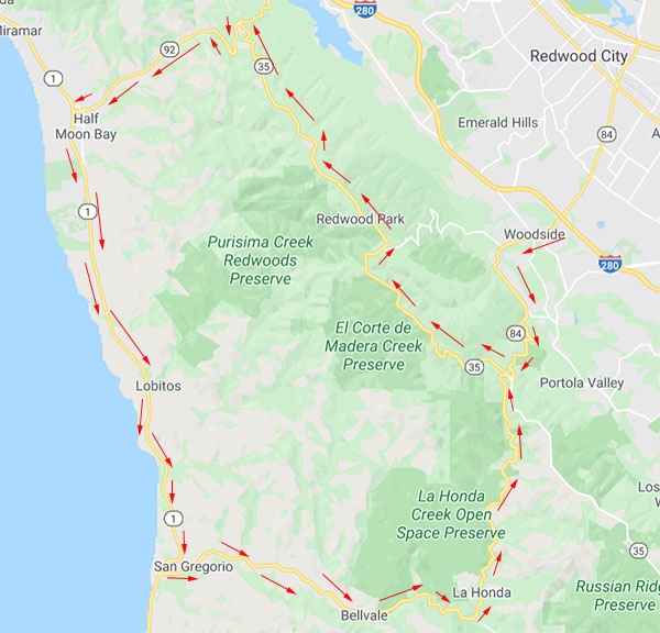
First, the route: It’s a quick hop down the 280 to the Woodside exit (that’s Highway 84), and then a twisty ride west on the 84 to Highway 35. Highway 35 is called Skyline Boulevard, which runs north to Highway 92, and 92 drops down to Half Moon Bay. Then it was another left onto the world-famous Pacific Coast Highway. I had an interesting stop at a very old cemetery just off the PCH, and after that I continued south to San Gregorio State Beach. Another left put me back on 84 and on into La Honda. From there, the 84 completed the loop. Here’s what it looks like:
The area to the west of 280 is surprisingly rural for a location so close to San Francisco (about 30 miles to the north) and Silicon Valley (which sort of starts just on the other side of 280). Highway 84 is a quick ride to the first town on this loop, and that’s Woodside.
Woodside is one of the wealthiest towns in America. A partial list of the big names who live or have lived in Woodside include Charles Schwab (yes, that Charles Schwab), Steve Jobs, Michelle Pfeiffer (the classiest actress ever), Joan Baez, Nolan Bushnell (the founder of Atari and the Chuck E. Cheese restaurant chain), Scott Cook (the founder of Intuit), Carl Djerassi (a novelist and the guy who developed the birth control pill), Larry Ellison (the CEO of Oracle Corporation), James Folger (as in need a cup of coffee?), Kazuo Hirai (the CEO of Sony), Mike Markkula (the second Apple CEO), Gordon E. Moore (Intel’s co-founder and originator of Moore’s Law), Prince Vasili Alexandrovich (the nephew of Tsar Nicholas II of Russia), Shirley Temple, John Thompson (Symantec’s CEO), and Nick Woodman (founder and CEO of GoPro). Woodside is within commuting distance of Silicon Valley, so it’s understandable, I guess, why so many high-rolling Silicon Valley types call it home. Needless to say, I didn’t bump into any of these folks on my ride (if I had, you’d see photos here). Given the choice, I’d like to meet Michelle Pfeiffer, but it just wasn’t in the cards that day. Charles Schwab would be cool, too, as Charles Schwab & Company have done well for me. Maybe next time.
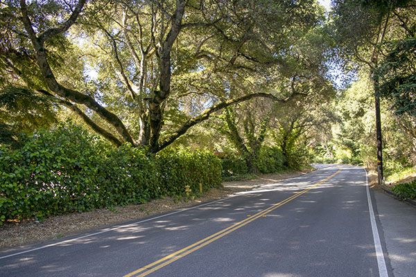
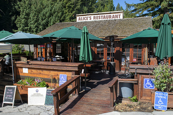
After passing through Woodside and climbing into the Santa Cruz Mountains, it’s on to the intersection of Highways 84 and 35. Alice’s Restaurant is right at that intersection. Getting there was fun. The road has 15-mph hairpins and there are redwoods, eucalyptus, and other tall trees on either side. In many cases they form a green leafy tunnel over the road. I would have liked to grab a photo or two, but there was literally no place to stop and truth be told, I had my hands full.
It’s only about 3 1/2 miles from the 280 to Alice’s on Highway 84. Before you get too excited, it’s not that Alice’s Restaurant (you know, the one in the Arlo Guthrie song). But the woman who started this restaurant is named Alice, and hey, why not ride that coattail? I was there during the week and I was able to get a photo of the place. When I went by on an earlier weekend, Alice’s was jammed with people, motorcycles, and Ferraris.
Highway 35 is called Skyline Boulevard. I think of a boulevard as a city street, but this was nothing like that. It was another twisting mountain road and the views were stunning.
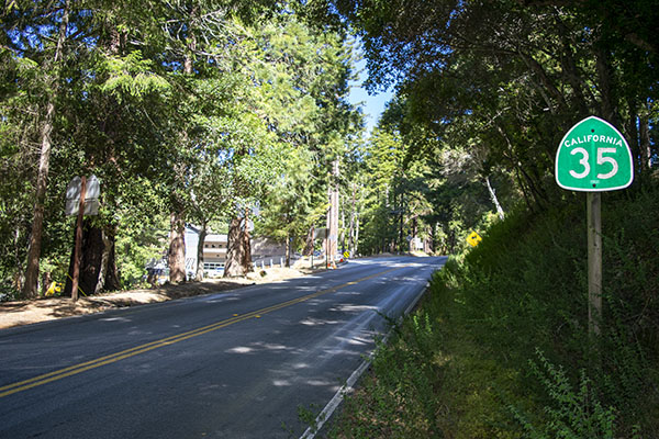


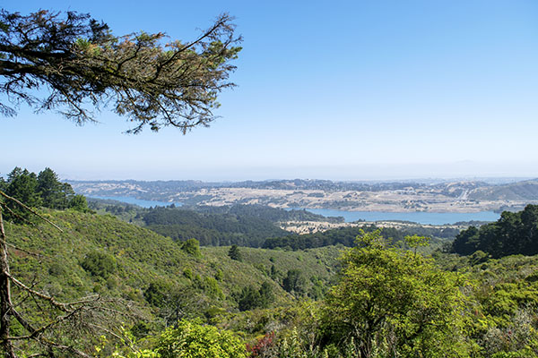
Skyline Boulevard tees into Highway 92 at its northern end and my ride along it was only 13 miles, but 13 miles can take a while on mountain roads. Part of it is the twisting nature of the roads and part of it is the scenery. I had the road to myself and it was awesome. Skyline Boulevard follows the ridge of the Santa Cruz Mountains. There are places where you can see San Francisco Bay looking to the right, and the Pacific on the left. The photo below shows the Crystal Springs Reservoir to the east, and if you look real hard, you can almost see San Francisco Bay beyond it.
When I reached Highway 92, another quick 5.4 miles brought me to Half Moon Bay.

Highway 92 has twists and turns, but it’s a busy road and Half Moon Bay is a tourist place. Not needing any refrigerator magnets and having been there many times before, I didn’t stop in Half Moon Bay on this ride. But it’s a cool place and based on my earlier visits, it’s impossible to find a bad restaurant (my favorite is the Greek Taverna on the left side of 92 as it nears the PCH; it’s a great walkup place for fresh seafood). Bring money; things are not cheap in Half Moon Bay. The major employer is the Ritz Carlton Hotel (it’s that kind of place).
Another interesting tidbit about Half Moon Bay: They used to host big wave surfing competition here. They get 50 to 60 foot waves when conditions are right and the area attracts the best surfers in the world. The organizers moved the competition someplace else about three years ago. Me? I’ll stick to something safer, like riding motorcycles.
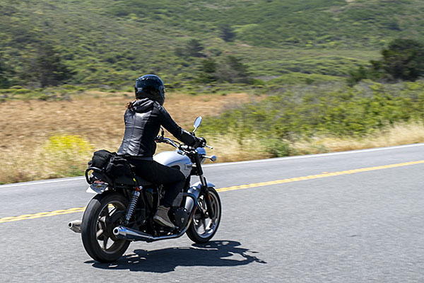
Highway 92 ends at the Pacific Coast Highway (also called the Juan Cabrillo Highway) and it runs long the Pacific for about a dozen miles before our next turn comes up (and that’s Highway 84 again, to complete our loop). Even though the road is the Pacific Coast Highway, it’s a fair way off to the Pacific and for most of that distance I couldn’t get a photo with the road and the ocean in the same frame, but hey, it’s the PCH, man. It doesn’t get much better than that, as these two Triumph-riders near San Gregorio State Beach already knew (where I finally did get the photo I wanted).

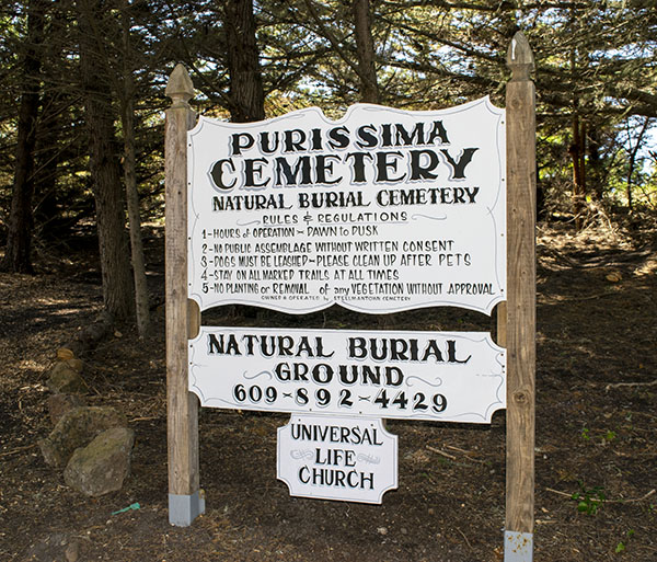
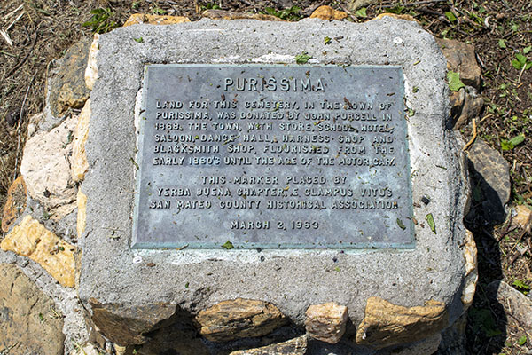
Before I reached San Gregorio State Beach, though, I had a stop I wanted to make. In researching this area before the ride, I discovered that there’s a ghost town and an old cemetery about four miles south of Half Moon Bay. It’s Purissima (with two “s”s), not to be confused with the La Purisima Mission, the subject of a recent ExNotes blog. The town of Purissima is long gone, but the cemetery is still there, and I stopped for a few photos. It’s a left on Verde Road, and the cemetery is about a half mile up the road.
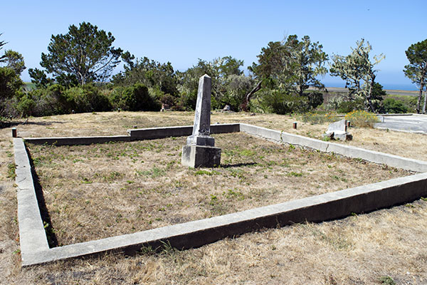


I like old cemeteries. After snapping a few photos, I was back on the PCH pointed south.
Eight miles down the road at San Gregorio State Beach I made a left on Highway 84. The town of San Gregorio is just up the road. There’s not much there, but the people are friendly. When I stopped for a shot of their general store there was a guy with a white beard taking in the day. When he saw me taking pictures, he asked if I wanted him to move. “No way,” I said. “Stay right there. You add character to the place.”

The Spaniards were the first Europeans to pass through this area in 1769 when they were expanding the Alta California mission chain. They stayed for a bit and named the area San Gregorio after Pope Gregory I. San Gregorio became a favored 1850s destination when San Franciscans visited the area for swimming, fishing, and hunting. Grizzly bears used to live in these hills, you know. And mountain lion. And deer (the ones the mountain lions didn’t get). I’ll bet the hunting was good. I’ve hunted California’s coastal mountains a hundred miles or so further south (we were chasing wild boar, but all I ever got was poison oak). The thought of going after a grizzly bear with a single-shot muzzleloader 170 years ago crossed my mind more than a few times as I rode through this area.
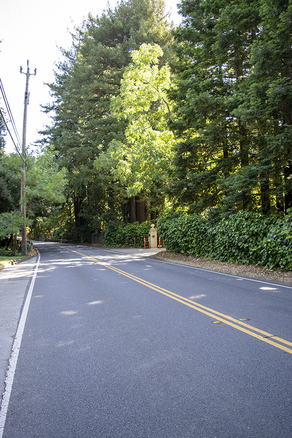
Further up the 84 (heading east) I entered the tiny town of La Honda (the name means “the sling” in Spanish). Impressive redwood trees made me stop for a photo, but before I could get to the trees this motorcycle whizzed by:

La Honda is a nice little place. I chatted with an old guy who had an English bulldog. I say old, but he was probably about the same age as me. “I did that once,” he said. “Stopped because my car was making a noise and decided this is where I was going to retire.” We had a nice conversation. He’s a former aerospace guy like me, and we talked shop for a bit about the good old days. You know, when the cold war was still in a full tilt boogie and the aerospace industry was the closest you could get to Heaven without a one-way ticket.
La Honda is a wide spot in the road that isn’t very wide at all, but it sure has a colorful background. The outlaw Cole Younger and his brothers used to live here. That’s the Younger brothers who ran with Jesse James (the real one, not the reality TV dude). The Younger brothers hid out in La Honda because it was cool and it was remote. Ken Kesey lived here (he wrote One Flew Over The Cuckoo’s Nest), and his drug-fueled La Honda exploits with Hunter S. Thompson and Tom Wolfe are documented in Wolfe’s The Electric Kool-Aid Acid Test. And like I mentioned above, grizzly bears used to live in these mountains. There are stories about a guy who survived a grizzly attack by killing the bear with his knife (not Davy Crockett, but the two would have probably got along). Fewer than a thousand people live in La Honda (at least as recorded by the last census). It’s a cool place made even cooler (literally and figuratively) by the giant redwood trees in the area.
So, about those redwoods:

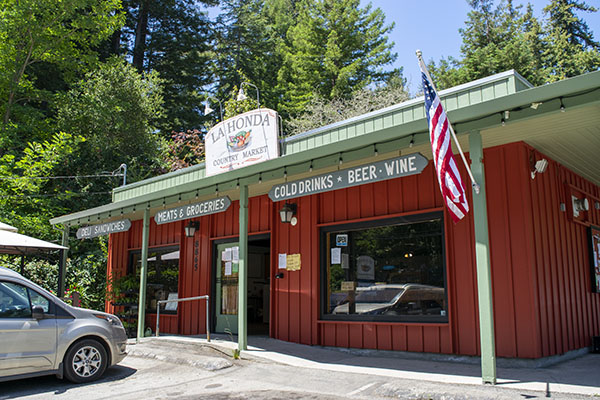
I was hungry when I reached La Honda. I usually select a place to eat based on how many vehicles are parked in front (who needs Yelp?) and by that measure, the La Honda Country Market looked mighty inviting (I had to wait for other folks to leave to get the unobstructed photo you see below). The Country Market has a killer deli bar. I had a pastrami sandwich on toasted marbled rye and it was maybe the best pastrami sandwich I ever had. Give it a shot. You can thank me later.
I’m up in this area fairly regularly, but this is the first time I’ve done the loop described here. It’s a great ride best done during the week. Because it is such a great ride (and because it’s close to both Silicon Valley and San Francisco), these roads are jammed on the weekends (motorcycles, Ferraris, Lamborghinis, Cobras, McClarens, and other motoexotica). When I did the ride on Tuesday, the roads were delightfully open.
I’d advise avoiding speeding (especially on the weekends, as the roads had a significant CHP presence) and I’d also say don’t wear a tinted visor. The giant redwoods and eucalyptus trees bathe the roads in alternating patches of bright sunlight and deep shade (the riding equivalent of chiaroscuro), and in the shade it’s tough to see through a dark visor.
The ride I described above is about 60 miles from the point you exit the 280 until you get back on it, as shown in the map at the top of this blog. I’d allow about two hours for a relaxed ride during the week, and maybe throw in another hour or two if you want to stop for breakfast or lunch.
Want to see our other rides on one of the greatest roads in the world? That would be California’s Pacific Coast Highway, and you can see it here.
Great ride, could hardly ask for a better day loop
It was indeed a grand ride.
I cut my motorcycling teeth on all those roads in the ’70s and’80s. I logged many, many thousands of miles riding at speed from HMB to Santa Cruz on hwys 35,84,92 and Stage Road (and others) every weekend early morning before the tourists and dweebs woke up. We’d get back to Alices by 11 a.m. or so and relax in the parking lot, our intense riding done for the day. Unforgettable, amazing times before the internet, the personal computer and cell phones. It was fantastic.
Well said. The roads are fantastic.
Mmm, pastrami sandwich. Jamakin’ me hungry…
Nice little day tour, Joe. Thanks for the photographic tour!
The pleasure was all mine.