By Mike Huber
This is a continuation from my previous blog highlighting ten of the best roads in the beautiful state of California.
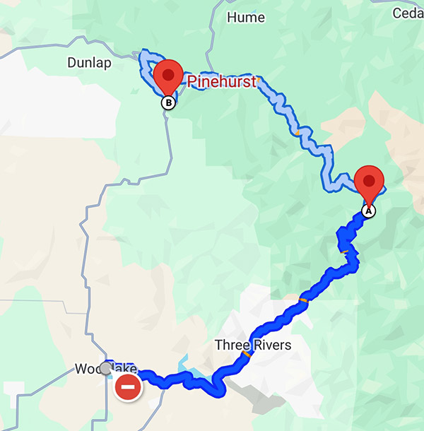
California 198 to Sequoia National Forest
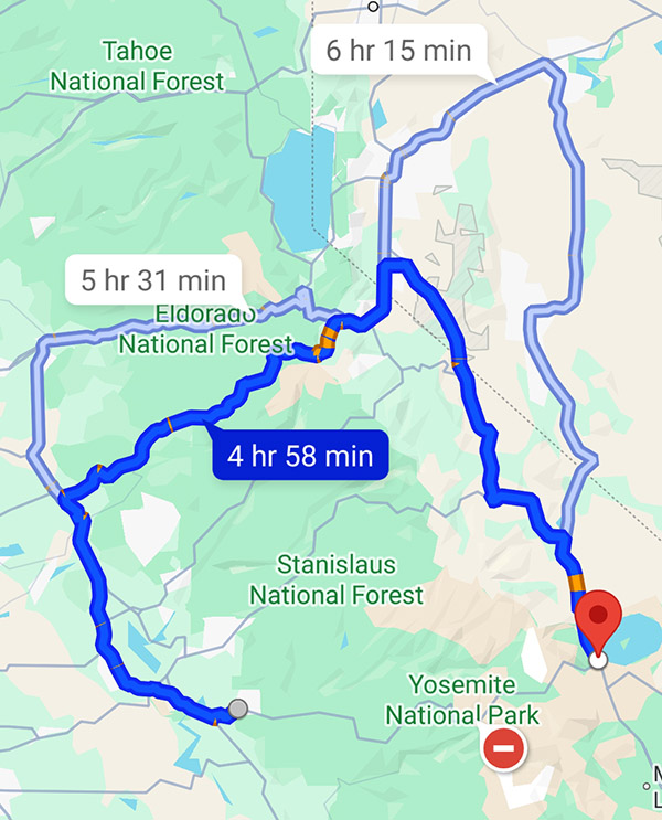
Rated 5 Wheelies Route Details. Yes, another mind-blowing road that goes through another National Park. This route has beautiful mountain switchbacks with no towns and minimal distractions. This allows you to lose yourself while focusing on the tight corners as you speed next to some of the largest trees on the planet. This route highlights how small you as a rider next to these majestic trees in Sequoia National Park.
-
- Start to Finish Points: Wood Lake to Pinehurst
- Distance: 78 miles
- Ride Time / Recommended Time: 3 to 6 hours
- Recommended Time of Year: May to October
- Main Point Of Interest(s): General Sherman Tree
- Cautions / Dangers: Wildlife in early morning and evenings
- Important Contact Numbers: CHP (Visalia) 559-734-6767
Road Description. Although this route can be completed in a day, I would recommend you take two days. The reason for taking this slower is to allow yourself to stop and enjoy the sightseeing along this national park. The road is in excellent condition as you climb the switchbacks to crest the highest point in the park. There are no gas stations along this route so it is imperative that you fill up in either Three Rivers or Hume Lake (75 miles between the two) or outside the northern part of the park near Squaw Valley (90 miles from Three Rivers).
Points of Interest. Since this is a National Park there is plenty to do outside of riding including hiking, sightseeing, and camping. This is one of my favorite National Parks since it is so stunning but everything is a very short hike to get to. Some of the largest trees in the World reside in this park. The General Sherman Tree is the world’s largest tree and is along this route. There are many other gigantic trees that are awe inspiring and shouldn’t be missed. These are the points of interest I recommend:
Where to Stay/Camp. Camping and hotels are limited to what is available in the National Park. Reservations should be made ahead of time as the park can often be booked full and will leave you no other options for 50+ miles for a place to stay. Here’s where to check:
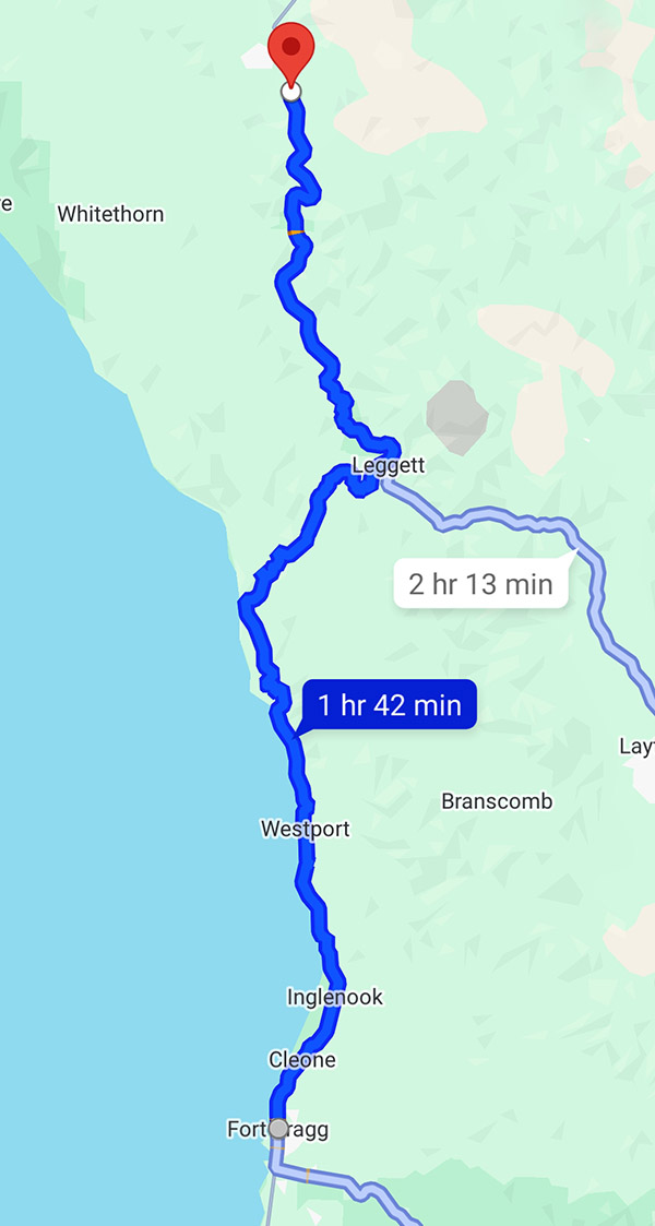
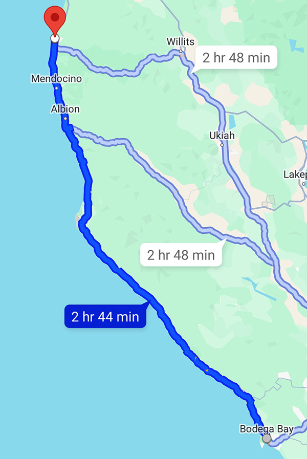
Fort Bragg to Bodega Bay on Highway 1
Rated 4 Wheelies
Route Details. This route can be combined with the Fort Bragg to Garberville route, but I wanted to ensure they were written on separately as I feel the riding and terrain changes from the previous one to this route. This is Northern California at its finest. Pristine ocean views that include lighthouses and beaches for over 100 miles.
-
- Start to Finish Points: Fort Bragg to Bodega Bay
- Distance: 107 miles
- Ride Time / Recommended Time: 3-6 hours
- Recommended Time of Year: May to Oct
- Main Point Of Interest(s): Numerous Beaches and Lighthouses
- Cautions / Dangers: Possible heavy fog in the morning
- Important Contact Number: CHP (Ukiah) 707-467-4420
Road Description. Beautiful sweeping corners that hug the cliffs consume this ride. You can feel your lungs cleanse as you breathe in the mist of the Pacific Ocean while blasting along one of the most well-known, yet less traveled roads in our country. The road is in great condition and there are plenty of small Oceanside towns that have locations to fuel up and allow you to stop in for meals or a beverage. It is important to ensure you soak up some sun while taking a breather and meet other riders at one of the many stops along this epic part of Highway 1.
Points of Interest. This stretch of Highway 1 has some of the most beautiful and unpopulated beaches in the country along it. There are several lighthouses that are worth stopping by to visit. Mendocino Headlands State Park is a perfect place to stop and get a short hike in to regain focus for the upcoming curves you will be leaning heavily into. There are also several small beach communities like Mendocino, Fort Ross, and Gualala you will ride through, any of which make for a great stop for lunch or a stayover if you have the time. Here are my favorite spots:
-
- Mendocino Headlands State Park
- Trillium Café is a wonderful tranquil location for lunch and a glass of wine
- North Coast Brewing is a good spot for great beer and a burger; it is the best I have found
- Point Arena Lighthouse
Where to Stay/Camp. This stretch of road is one of the easier places to locate campgrounds and hotels due to the lack of crowds along it. As always making reservations ahead of time is recommended to ensure you have a safe place to rest for the evening. I have always had a pleasant experience staying along this route. Any of these places are good:
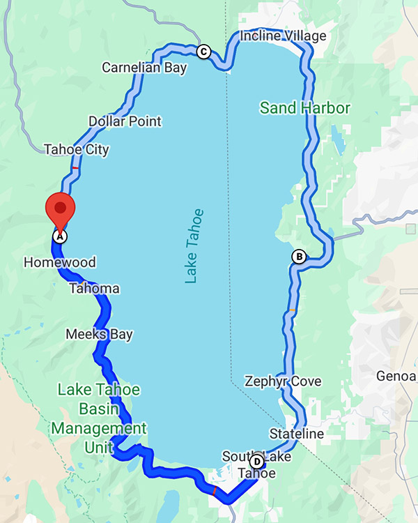
Northern Tahoe Loop
Rated 4.5 Wheelies
Route Details. 113 miles of diverse riding from open field to challenging switchbacks as you climb the cliffs along beautiful Lake Tahoe and take in some of the most intense roads and vistas in California. The road is in excellent condition with much of it newly paved. There are plenty of turnouts for taking photos, which is fortunate because the curves are very sharp and come up quickly so the ability to pull over and take in the views is an added bonus along this trip. The route is not a letdown. You and your motorcycle will be smiling all day.
-
- Start to Finish Points: Kings Beach with Reno Junction in the north as your turnaround back to Kings Beach
- Distance: 113 miles
- Ride Time / Recommended Time: 4 to 6 hours
- Recommended Time of Year: May to September
- Main Point Of Interest: Lake Tahoe, Reno
- Cautions / Dangers: Quickly changing weather conditions, especially in fall
- Important Contact Numbers: CHP (Truckee) 530-563-9200
Road Description. This is one of the more picturesque and challenging rides in California. This route provides such a range in diversity, both in the scenery and the road types. You start in Kings Beach where there are rolling meadows and begin to quickly climb to over 9,000 ft. where you will be skirting the edges of cliff sides with some serious switchbacks thrown in for added intensity. This road is not for beginner riders as the technical cornering along with the beautiful views can be too dangerous for a novice to safely navigate, however, for seasoned riders on a clear day the photos from this ride will soon be the background on your laptop screen.
Points of Interest. This route has plenty of tourism along Lake Tahoe and in Reno as you loop through the stunning Tahoe National Forest. There are plenty of pullouts along this route to catch your breath and absorb the beauty that is fully surrounding you. As you traverse this loop you will not have to worry about any long stretches without gas or places to stop for food. Here are a few favorites:
-
- Gar Woods Grille & Pier is the perfect place to start or end your day with great food, beautiful views of the lake, and live music on the weekends
- Brewforia is perfect lunch location with excellent craft brews and delicious burritos
- The Peavine Taphouse in Tahoe at the top of the loop it is worth pulling in to get some heavily loaded pizza to fuel up for the return trip
Where to Stay/Camp. With Tahoe National Forest surrounding you there are plenty of opportunities for dispersed camping along this ride. There is also an abundance of hotels, both high end and budget as well as state and private campgrounds. In short there is no need to worry about finding a place to lay your head and recover or to prepare for an incredible day of riding here.
-
- US Forest Service Campground
- KOA on northern portion of the loop
- Lakeside Hotel with all the amenities you could desire
- Pepper Mill Casino/Hotel in Reno, on northern part of loop
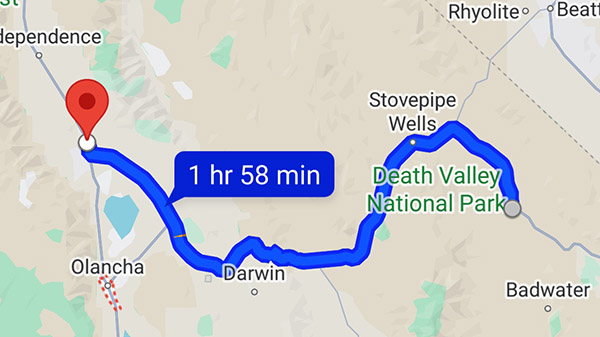
Death Valley Highway 190
Rated 4 Wheelies
Route Details. This road is quite unique from any other road in this state. It is 135 miles of just raw desert. Ensure you carry extra water to drink although there are gas stations every 35 miles or so. However, with this area having some of the hottest weather on the planet keeping an extra gallon of water (at least) on you is a wise move. The road is as desolate as you can find on a motorcycle, and the topography is like something from another planet. Even though the roads are straighter as compared to other rides I have listed, it’s the region and scenery that really make this road jaw dropping. Be very aware of the weather prior to traveling through this area.
-
- Start to Finish Points: Lone Pine to Death Valley Junction
- Distance: 135 miles
- Ride Time/Recommended Time: 4 to 6 hours
- Recommended Time of Year: September to early May
- Main Point Of Interest: Death Valley National Park
- Cautions/Dangers: Extreme heat conditions, possible sand in road
- Important Contact Numbers: CHP (Bishop) 760-872-5150
Road Description. If you’ve ever dreamed of driving a motorcycle on Mars this is what it would be like. This road is one that you will never forget due to the dramatic landscape and post-apocalyptic feeling as you roll through the desolate desert of this National Park. The temperatures are extremely hot so I will mention this again to confirm the weather prior to embarking on this route. Early morning is a perfect time to go if you are traveling east to west to watch the landscape change colors in front of you while you are riding.
Points of Interest. The main attraction of this part of the country is Death Valley National Park. This area is home to the lowest point in the southern 48 with an elevation of 280 feet below sea level. As you stand in the depths of that point and turn northward you can see Mt. Whitney in the distance. Mt. Whitney is the highest point in the lower 48 rising up at over 14,000 feet. During springtime the desert erupts with beautiful fields of wildflowers that stretch across the desert. This makes February and March one of the best times to visit this area. This time also provides relief from the extreme heat of this National Park. There’s more info on Death Valley National Park here.
Where to Stay/Camp. This road has only a few places to stop along the way so it is important to ensure your water and fuel levels are topped off at each stop. Even though there are so few places to eat there is plenty of camping along the way during cooler months. Here are the spots I recommend:
-
- The Panamint Springs Hotel is the only place in Panamint Springs to get food, water, and a hotel room
- Just prior to entering the National Park the Death Valley Hotel is the perfect mid-way point to either grab lunch, camp or a hotel room
- The Oasis at Death Valley resort has a great steakhouse and saloon that is perfect for a beverage to wind out your day; on the eastern side of the park this resort will be a welcome break from the heat of the day
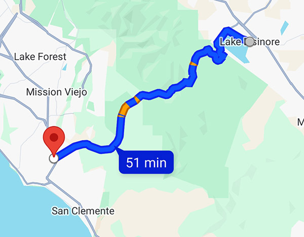
San Juan Capistrano to Lake Elsinore on Route 74
Rated 4 Wheelies
Route Details. This is a perfect ride for a Sunday afternoon to wind down from the weekend. Fun switchbacks up through the Ronald W. Caspers Wilderness. The road has some beautiful pullouts for a panoramic view of the lake right before you descend down into the town of Lake Elsinore. This ride is popular with local riders so be aware of that as you travel through it and be mindful of speed traps.
-
- Start to Finish Points: San Juan Capistrano to Lake Elsinore
- Distance: 52 miles
- Ride Time / Recommended Time: 2 to 4 hours
- Recommended Time of Year: Year round
- Main Point Of Interest(s): Lake Elsinore
- Cautions / Dangers: Speed Traps
- Important Contact Numbers: CHP (San Juan Capistrano) 949-487-4000
Road Description. Beautifully maintained roads where you can really practice cornering on your motorcycle. This road is more of a social route that will allow you to stop and chat with fellow riders and build new friendships than a long distance run. It’s close in proximity to LA which makes it a perfect ride on any day where you have a few spare hours and are in need of wind therapy.
Points of Interest. Once you leave San Juan Capistrano there is nothing until Lake Elsinore, except for probably one of the coolest motorcycle bars I have ever visited, Hell’s Kitchen Motorsports Bar and Grill. This is a place you have to stop at along this road to meet other riders and get a beverage and a burger. There are also several hikes with waterfalls that are worth stopping by for a break and to stretch out.
-
- The Ortega Waterfalls is a lovely place to rest and take a quick swim, located at 33382 to 32806 Ortega Highway in Lake Elsinore, California
- Hell’s Kitchen Motorsports Bar and Grill is a great stopping point to meet other riders and car enthusiasts
- Kristy’s Country Store is the only place along this route to get snacks or water
Where to Stay/Camp. Surprisingly for such a short stint of road there are several wonderful camping opportunities either along the beach or in the hills along Route 74. All the campgrounds along this road are very clean and well maintained. These can allow for a weekend getaway that isn’t too far of a ride to get some air and enjoy a nice fire glowing off your motorcycle as you unwind from a week at work.
-
- Doheny State Beach is a great location for beach camping
- The Orange County Park area is a perfect campground with short hikes you can start right from your campsite; closer to Lake Elsinore, this campground also has some short beautiful hikes that are closer to the waterfalls
Conclusions
As you can see there is no shortage of beautiful roads in California. These routes listed along with the bars, restaurants, and tourist points are some of my favorites in the state. The experiences you embrace along these roads are sure to create some of the fondest memories that will stay with you for a lifetime. If you found this article useful or would like to share your favorite roads and experiences in California please feel free to share so we can work together to expand our knowledge on this unforgettable state.
Never miss an ExNotes blog:
Don’t forget: Visit our advertisers!