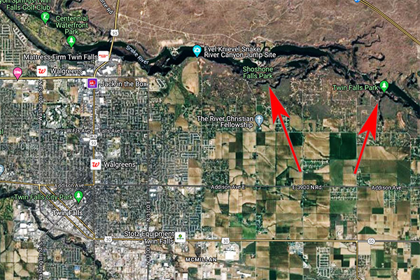
The question I found confusing when navigating my way to Twin Falls, Idaho, was this: Is Shoshone Falls the “twin falls” referred to in Twin Falls, or is there another set of falls somewhere along the Snake River? I never really had a satisfactory, definitive answer to that question (and I asked several people in Twin Falls). It’s further complicated by the fact that upstream of Shoshone Falls (at the eastern edge of the town of Twin Falls), there’s another park called Twin Falls Park. I think the answer is this: There are other falls along the Snake River in the area of Twin Falls, but the Shoshone Falls are the two falls that give the city its name. If you know different, please let me know.
The arrow on the left points to Shoshone Falls. You can see how close the Falls are to the city of Twin Falls. The arrow on the right points to Twin Falls Park, which is also on the Snake River.
I plugged Shoshone Falls into Waze, and the nav program took us east out of town through a bit of farm country and past a few housing developments. The ride down to Shoshone Falls Park was an interesting one. When we approached the entrance where you pay $5 to enter the park and I asked about handicapped parking (I had a bad motorcycle accident 15 years ago and my handicapped parking tag was that cloud’s silver lining). The nice lady in the ticket booth told me my handicapped parking tag meant free admission. The month I spent in the hospital had a return on investment.
The ride down to Shoshone Falls from the entrance demands attention. It winds down a narrow lane alongside the mountain with a steep dropoff on one side (and there was no guardrail). I realized it would be best to save the sightseeing until I got down there.
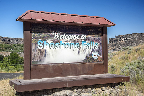
The sign upon entering the parking area.
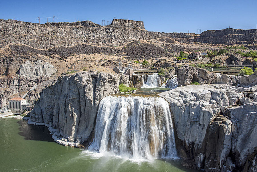
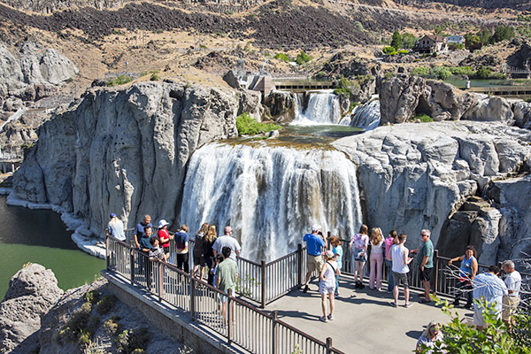
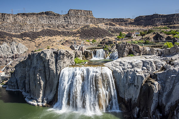
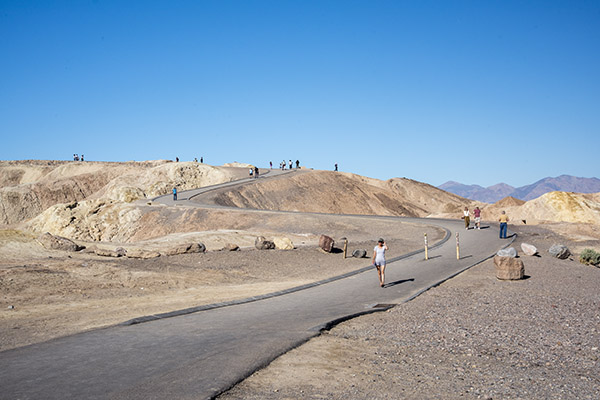
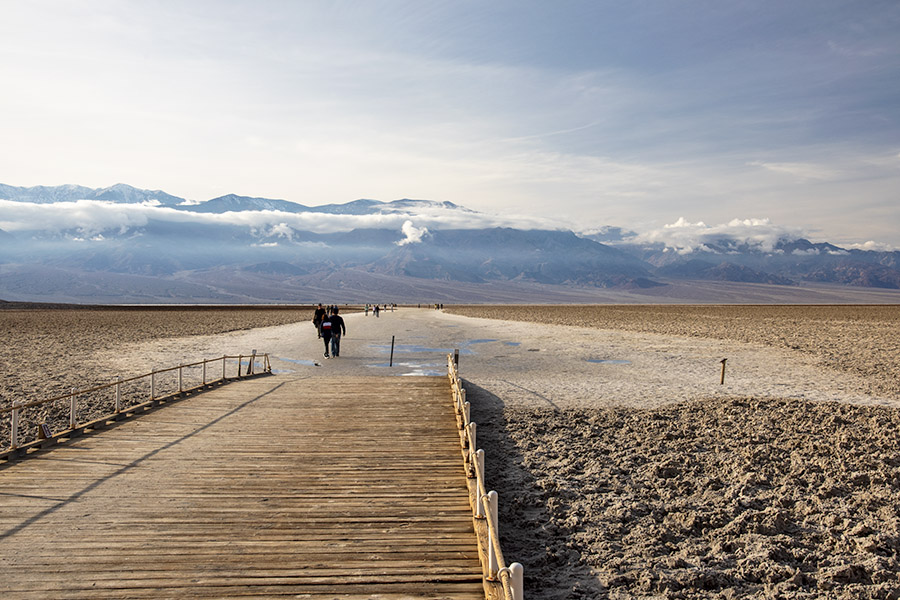
Once we arrived at the Shoshone Falls viewing area, we could see there are indeed two separate falls. It’s very scenic.
I stopped on the stairs leading to the viewing area. Our visit was nice and it wasn’t crowded.A photo of Shoshone Falls from the viewing platform.
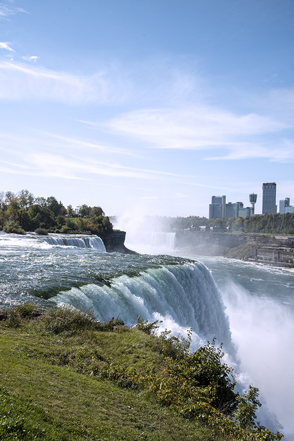
I’ve read online that Shoshone Falls is the Niagara Falls of the West, and Shoshone Falls has more of a drop than does Niagara. Shoshone Falls is a beautiful thing to see, but trust me on this, it’s not Niagara Falls. I’ve been to Niagara Falls. Shoshone Falls is nice, but there’s no comparing it to Niagara Falls.
Niagara Falls, from the US side. That’s Canada in the distance. I could feel the ground shaking when I shot this photo.
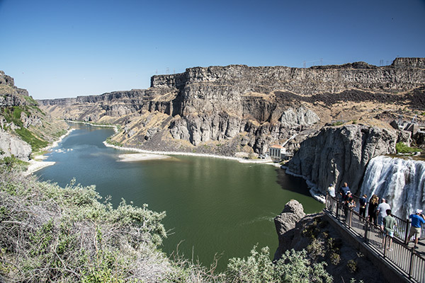
I looked down the Snake River. It was nice. It was scenic. I was glad we made the trip to Idaho. We were covering a lot of ground. I was getting great photos. Sue and I were on a content safari and Idaho was a target-rich environment.
The Snake River below Shoshone Falls. Just around the bend in the river is where Evel Knievel attempted to jump the Snake River Canyon. That story is the next blog in our Idaho series.
While studying the map to get to Twin Falls’ Shoshone Falls, I noticed that a bit downstream of Shoshone Falls along the Snake River the map showed the Evel Knievel Snake River Canyon jump site. There was no mention of it anywhere else. I wondered: Was it still there?
As mentioned in our introductory Idaho blog, I had briefly visited the Craters of the Moon National Monument on the 5,000-mile Western America Adventure Ride with the Chinese and other folks who owned RX3 motorcycles. Good buddy Baja John did all the navigating and planning on that ride; I just rode at the front of the pack and took all the credit.
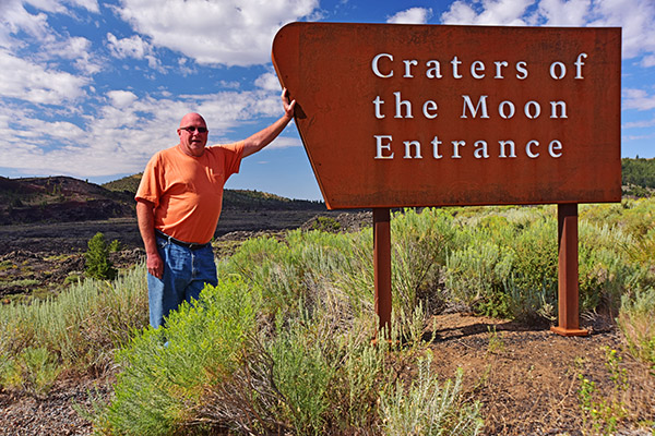
Baja John posing at the Craters of the Moon National Monument and Preserved entrance exactly 10 years ago. Tempus fugit, my friends.
We planned those early CSC trips as if it was just Baja John and me riding, and I figured on way too many miles each day. John and I can do 600-mile days easily. When we planned the larger Western America Adventure Ride, even 400-mile days were a huge challenge. A good rule of thumb on such larger group rides is to stick to a maximum of 200 to 250 miles each day. I didn’t know that then.
Anyway, on that first Craters of the Moon stop, we were on a big mileage day and we didn’t have too much time to spare. We pulled into the Craters entrance, grabbed a few photos, and continued our trek to Twin Falls. I recently wanted to do a Destinations piece on Craters for Motorcycle Classics magazine, and when I looked through my files, I found I only had a couple of Craters photos. That dearth of useable photos became part of the reason Susie and I visited Craters again.
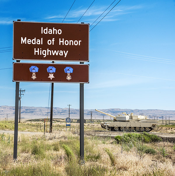
The ride from Boise (where Susie and I started that morning) to Craters takes you east on I-84 and then east on US Highway 20. As an aside, Highway 20 runs across the entire United States, from Newport, Oregon to Boston, Massachusetts. Part of Highway 20 in Idaho was designated as the Medal of Honor Highway by Governor Brad Little in 2019, and Susie and I took it to Craters.
US Highway 20, Idaho’s Medal of Honor Highway. The photo ops through this part of the world are impressive. Bring a polarizer.Idaho is justifiably proud of its Medal of Honor winners. That’s an M1 Abrams tank in the background, a turbine-powered, 70-ton beast that can hit 60 mph and fire on the move with great accuracy. Three Medal of Honor recipients currently live in Idaho; as many as 48 people awarded the Medal of Honor have an Idaho connection.
After Highway 20, it’s a left turn onto Highway 26 to get to Craters of the Moon. It’s more scenic riding, including the towns of Carey and Picabo. Carey is where we had a comical encounter on the Western America Adventure Tour when riding with our Chinese compañeros across Idaho. On that day 10 years ago, it happened to be Pioneer Day. We didn’t know that, nor did we know that there was a parade in Carey. I was in my usual spot (in front of the pack), Gresh was riding alongside me, and our group of a dozen RX3 riders were right behind us. As we approached Carey, local residents lined the streets. Many were holding American flags. They waved and cheered us as we rode into town. We had no idea what was going on. Gresh flipped his faceshield up and said, “Wow, a lot of people are following the blog” (I had been blogging our trip across the western US every day). We didn’t know it at the time, but we were only a few minutes ahead of the parade Carey was expecting, and those good Idahoans thought we were the advance guard. It was fun and it made for a great story (which I have told about a thousand times by now).
On US Highway 26 heading east into the Craters of the Moon National Monument and Preserve. Note the volcanic rock on either side of the road.
The good folks in Carey were not waiting for Susie and me on this trip, but we had a good time anyway. When we rolled into Picabo a little further down the road, we had an even better time when we topped off the Jeep and had lunch (which was excellent). I told you a bit about that (and the Ernest Hemingway connection) yesterday.
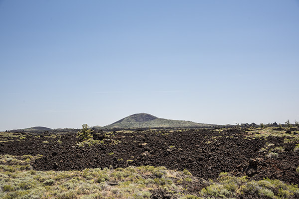
The volcanic flow in the Craters of the Moon National Monument and Preserve. That’s Echo Cone in the distance.
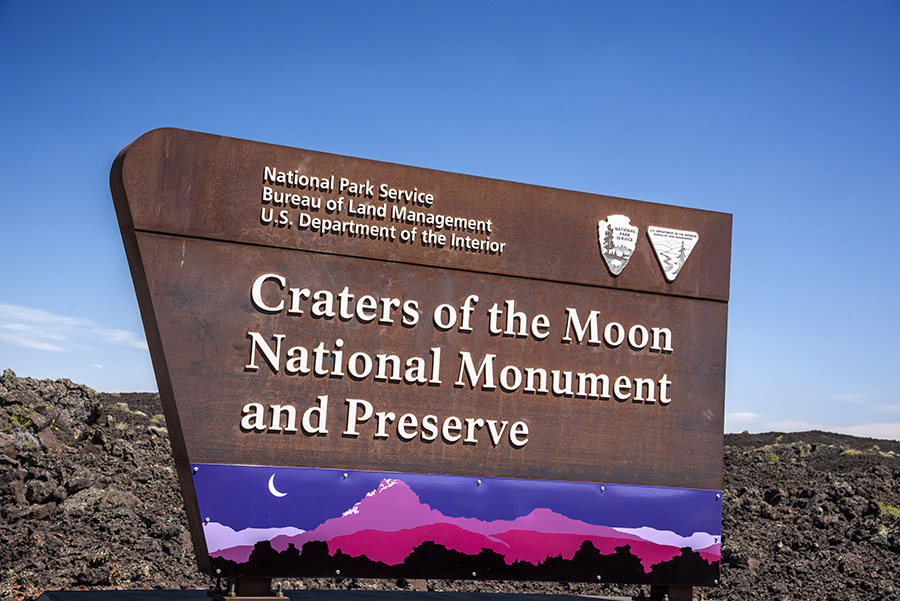
The National Park Service describes the landscape in and around Craters of the Moon National Monument and Preserve as “weird and scenic” and that’s an apt description. The landscape is almost lunar-like. Its alien features consist of mostly dark brown solidified lava surrounded and sometimes punctuated by patches of green vegetation. It makes for a dramatic landscape and awesome photo ops.
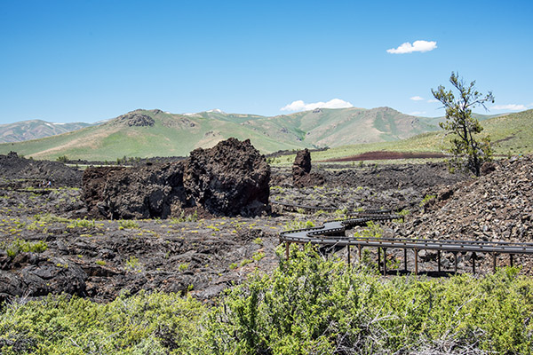
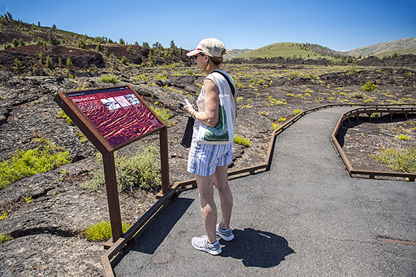
A walkway above the pahoehoe lave field.Sue reading about the pahoehoe lava. The National Park Service does a great job making these kinds of places accessible and providing explanations telling the story at each location.
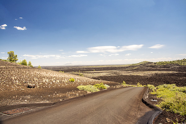
You can ride a designated, one-way, circular tarmac road through the Preserve, with paved offshoots for specific sights. One of the first stops is a pahoehoe lava field. The name is a particular type of lava, and it comes from the lava volcanoes and their flows in Hawaii. Pahoehoe lava is characterized by a rough and darkened surface. What made it even more interesting is the walkway above the lava. You can walk a loop of about a quarter of a mile and see what the hardened lava looks like. The walkway is a good thing; I don’t think it would be possible to navigate this terrain on foot.
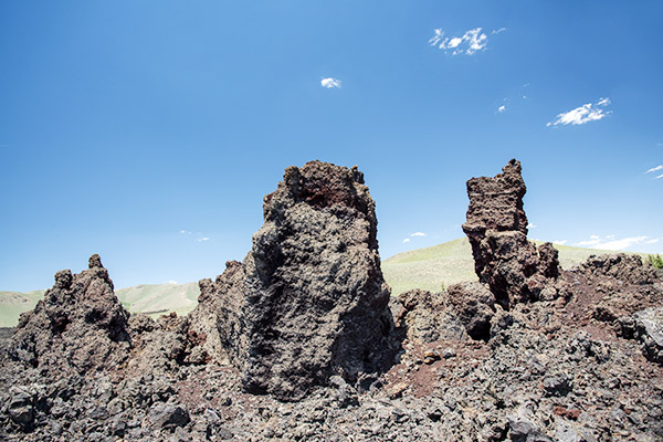
Monolithic cinder cone fragments in one of the lava fields.
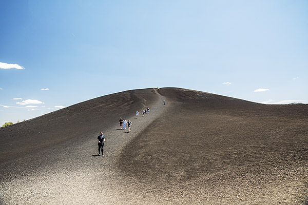
Another lava structure is called cinder cone. Sometimes these structures break apart and leave monolithic forms like those in the photograph above. One of the more dramatic areas in Craters of the Moon is the Inferno Cone. There’s a place to park near the base and you can climb to the peak.
The climb to the Inferno Cone peak. Sue did it. I watched.Completing the circular ride through Craters of the Moon. The lava formations to the left are called cinder bombs.
There are several lava tubes (caves formed by lava flow) in Craters of the Moon, and if you wish, you can hike into them. We didn’t do that. There are also longer hikes throughout the Preserve if you want to explore more.
There’s much to see and do at Craters of the Moon. How long you stay and how much you see is up to you. We were there for about three hours and we had a great visit.
The next stop on our Idaho expedition would be Twin Falls. That’s coming up, so stay tuned.
If you would like to read about the Western America Adventure Ride and how CSC rewrote the motorcycle adventure touring book, the story is here:
Good buddy Paul recently sent to me a video about the powder charges used by US Navy battleships. The USS New Jersey was featured in the video, and it reminded of my visit to a sister ship, the USS Alabama. I wrote a Destinations piece for Motorcycle Classics magazine ten years ago, and I thought you might enjoy seeing it (along with photos that did not appear in the MC article).
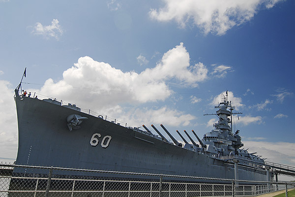
The coastal plains along Alabama’s southern edge are flat and the line of sight extends to the horizon. Ride east on Interstate 10 out of Mobile and you can see her distinctive, bristling profile from a great distance. One can only imagine the fear she induced in our enemies as she emerged from the mist on the high seas.
She, of course, is the USS Alabama. She’s docked at Battleship Memorial Park, just east of Mobile on I-10 where Alabama’s coast meets the Gulf of Mexico. To call the USS Alabama impressive would be a massive understatement. This magnificent old warship is a study in superlatives and in contrasts. Taller than a 20-story building, longer than two football fields, and capable of firing projectiles weighing nearly as much as a Z-06 Corvette at targets more than 20 miles away, the USS Alabama projected America’s power on the open oceans and inland during World War II. The “Lucky A” (she lost not a single crewmember to enemy fire while earning nine Battle Stars) sailed just under a quarter of a million miles in combat conditions and saw action in both the Atlantic and the Pacific theatres. When she passed through the Panama Canal, the 680-foot, 44,500-ton Lucky A had just 11 inches of clearance on each side.
After World War II the USS Alabama was retired from active service. In 1962 the Navy announced plans to scrap this magnificent ship due to the high costs of keeping her in mothballs, but the good citizens of Alabama would have none of that. Alabama kids raised nearly $100,000 in nickels, dimes, and quarters, and corporate sponsors coughed up another $1,000,000 to bring the ship from Puget Sound to Mobile.
The USS Alabama is in amazing condition; indeed, it looks as if the ship could go to war today. Being aboard is like being in a movie (Steven Seagal used it for the 1992 movie, Under Siege). It is an amazing experience eliciting a strong combination of pride and patriotism.
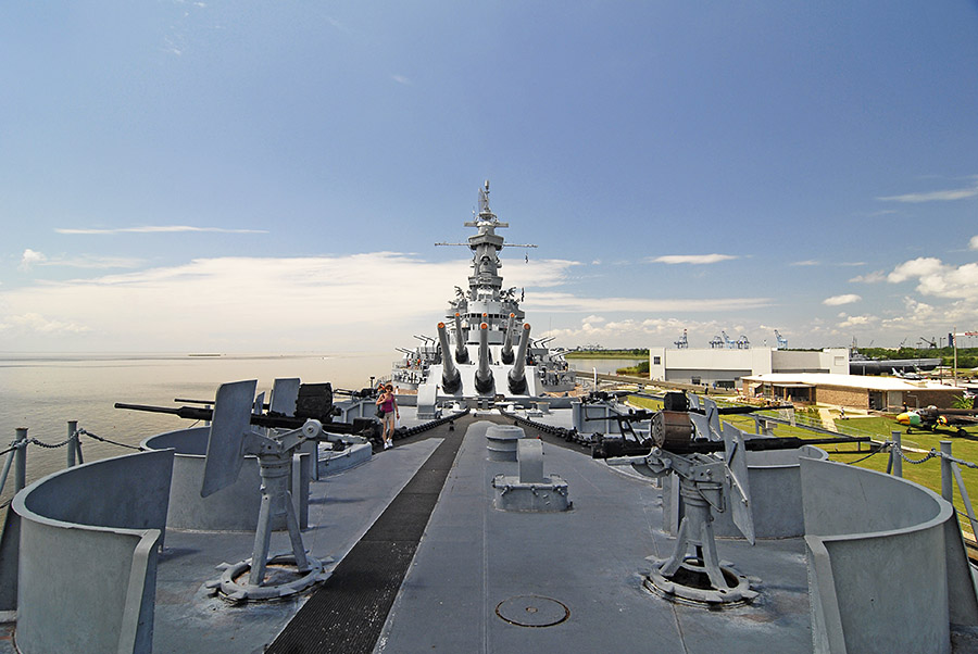
The USS Alabama is a floating artillery base. With armor more than a foot thick above the water line it’s amazing she could float at all, but the old girl could top 32 mph and she had a range of 15,000 nautical miles. When she stopped at the pumps, the USS Alabama took on 7,000 tons of fuel (a cool 2 million gallons).
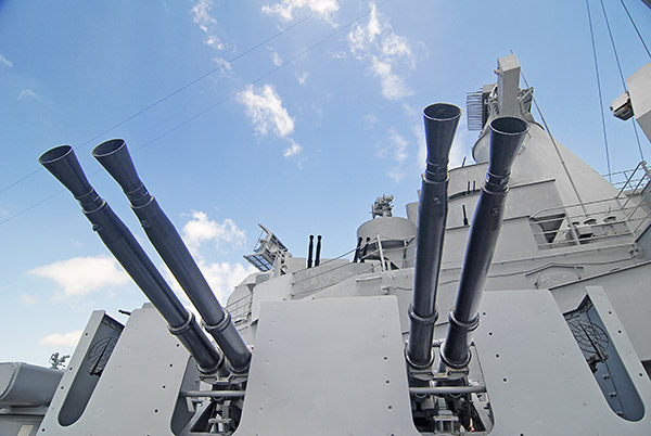
The guns are what impressed me most. The ship bristles with armament. The Alabama’s 16-inchers dominate everything. Approaching the ship highlights the big guns and when you get closer, they are stunning. Try to imagine nine 16-inch guns, three per turret, firing at our enemies (it must have terrifying). The ship boasts twenty 5-inch guns (two in each of the ship’s 10 smaller turrets). There are another 12 mounts with 48 40mm cannon. And just to make sure, the Alabama has another 52 20mm anti-aircraft cannon. If you’ve been keeping track, that’s 129 guns.
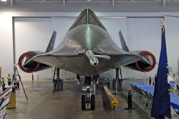
The USS Alabama is only part of the treasure included in Battlefield Memorial Park. The park includes the USS Drum (a World War II submarine), numerous armored vehicles, and an impressive aircraft collection spanning 70 years of military aviation (including a B-52 bomber, numerous fighters, the top-secret SR-71 reconnaissance aircraft, and assorted other planes). The USS Alabama could touch 32 mph on the high seas; the SR-71 cruised at 3,000 mph. The USS Alabama weighs a bit more than 720 million pounds; the SR-71 was built from lightweight titanium. As I stated earlier, the Park and its exhibits are a study in superlatives and contrasts.
Battleship Memorial Park is just east of Mobile on Interstate 10. You can’t miss it (the USS Alabama is visible for miles from either direction, even at night). Admission is only $15 and take my word for it, it’s the most bang for the buck you’ll ever get.
The Skinny
What: Battleship Memorial Park, 2703 Battleship Parkway, Mobile, AL 36602. An outstanding collection of land, air, and sea military vehicles, with the USS Alabama being the main attraction.
How to Get There: Interstate 10 from either the east or the west. From anywhere else, just head south until you hit Interstate 10 and point your front wheel toward Mobile.
Best Kept Secret: There have been seven US Navy ships named Alabama reaching back to before the Civil War. Today, a US Navy nuclear submarine sails under that same proud name.
Avoid: Missing Mobile. It’s a beautiful town, and its Gulf Coast location makes for great seafood and great hospitality.
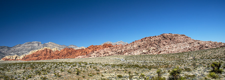
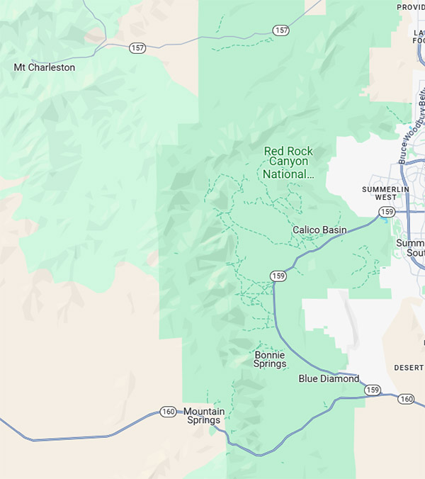
Red Rock Canyon National Conservation Area is an interesting spot located just west of Las Vegas. During our recent visit to Death Valley, we rode to the Red Rock Canyon area after stopping for lunch at Mom’s (a great restaurant) in Pahrump.
Pahrump is 30 miles northwest of Red Rock Canyon National Conservation Area on Highway 160; Las Vegas is 17 miles to the east.
The Red Rock Canyon National Conservation Area has a good plan for managing visitors. You have to make an online reservation that slots you into 15-minute arrival intervals. There’s $16 entrance fee (I guess it’s per vehicle), but when we arrived the park ranger didn’t even look at my senior citizen lifetime pass. He just waived us in. That’s happened to me a few times at National Parks. Maybe I just look old.
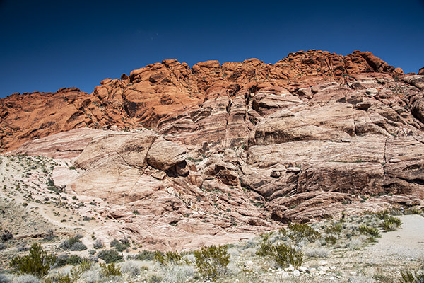
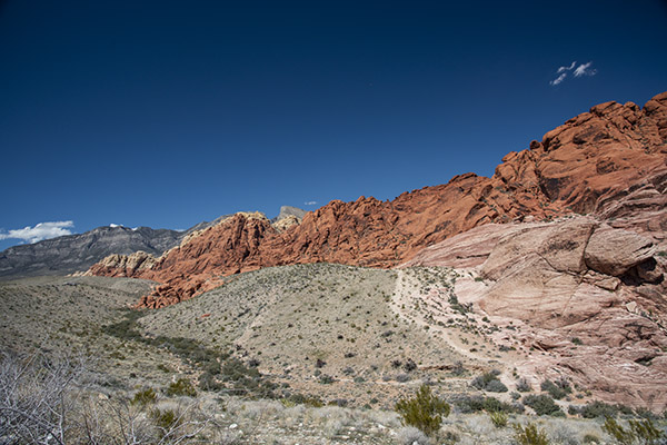
We took Highway 160 east from Pahrump and it was a pleasant ride. As we approached Red Rock Canyon National Conservation Area, the Spring Mountains on our left (north of Highway 160) had brilliant burgundy horizontal rock layers. The red is caused by iron oxide. We weren’t even in the Park yet, and the views were already stunning. It really is something to see.
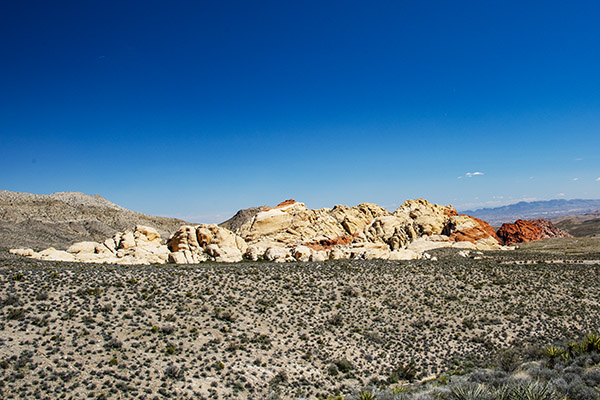
Once we entered Red Rock Canyon National Conservation Area, we explored the Visitor Center and four interpretive exhibits accessible via a walkway outside. After that, we started the 13-mile one-way ride through the park. There are many stops offering different views of the mountains and rock formations. Motorcycles are fine on this road, and we also saw people riding bicycles. I’d like to do the ride on a bicycle someday. It looked like fun.
Desert tortoises live here and there are exhibits that provide information about them. The tortoises live near Visitor Center paths, but we didn’t see them while we were there. That’s okay; I’ve seen desert tortoises out and about on previous treks. As an aside, if you happen to see one, don’t pick it up. Doing so will frighten the tortoise and literally scare the pee out of it, which can induce dehydration and kill the tortoise. The desert tortoise is a protected species, so leave them alone.
You can hike and camp in Red Rock Canyon National Conservation Area. When I read that I immediately thought of Mike Huber, who is wheeling and camping his way around New Zealand as I write this.
Although I’ve been to Las Vegas many times, I had never visited Red Rock Canyon National Conservation Area. It’s about as different from Las Vegas as a place can be, and in my opinion that’s a good thing. If you’re ever in this part of the world, Red Rock Canyon National Conservation Area is worth a stop.
I recently posted a couple of blogs about Death Valley, including a recap of my several visits over the last decade. This blog is a little bit different. it’s about some of the cool stuff near Death Valley. I didn’t have any hard rules about how close “near” means. I’m including the places I’ve visited and thought were worth a mention. If you think there should be more, leave a comment and tell us about it. We love hearing from you and we love when you click on the popup ads, so don’t forget to do so (and when you see that donate button at the bottom of this blog…well, you know what to do).
I shot most of the photos in this blog with my Nikon D810 and the 24-120 Nikon lens. A few were with the Nikon N70 film camera I recently wrote about, and where that is the case, I’ll say so in the photo caption.
Baker
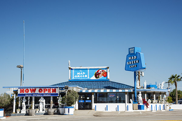
When visiting Death Valley from the south (as in southern Calilfornia), it’s likely you’ll pick up Highway 127 in Baker, just off Interstate 15. There used to be a hotel in Baker, but it’s gone. There are a couple of gas stations a couple of tacky fast food franchises, but don’t waste your time eating in a fast food franchise. What you want is the Mad Greek.
The Mad Greek restaurant in Baker, California.
I didn’t eat at the Mad Greek on this trip (either coming to or leaving Death Valley). Sue decided several trips ago she didn’t like the place, so I deferred to her wishes. I never know when I might want to buy more reloading components, another gun, another watch, or another motorcycle, so we took a pass on the Mad Greek (Sue is of Greek ancestry; maybe that has something to do with it). When I ever pass through Baker on my own, though, the Mad Greek is a sure thing.
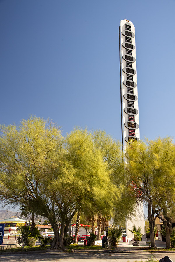
The Baker thermometer. If you are going to visit Death Valley, the winter months are very comfortable (it was 68 degrees when I took this photo). It gets warmer in the summer.
The other thing Baker is famous for is its thermometer. It’s 134 feet tall, in honor of reaching that record temperature in 1913 (I guess we had global warming back then, too). If you go through Baker, you have to get a photo of the Baker thermometer. It’s a rite of passage.
Highway 127
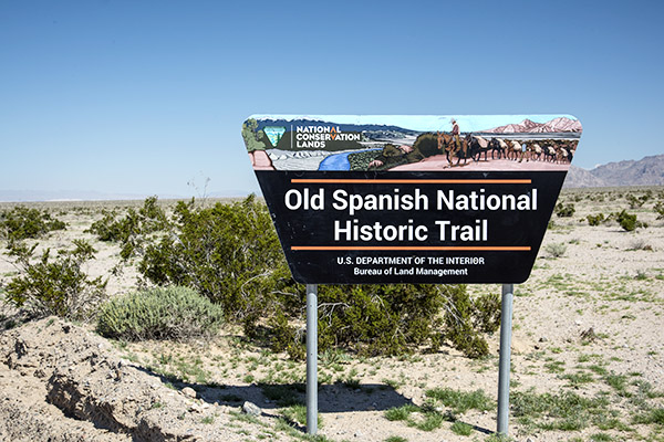
The signs are new; the Old Spanish Trail is not.
The ride north through the California desert from Baker to Death Valley is both beautiful and historic. It follows the Old Spanish Trail, something I had never of until I saw the signs and did a little research. Established in 1829, the Spanish Trail is a 700-mile long road that runs from Santa Fe to southern California. It traverses New Mexico, Colorado, Utah, Arizona, Nevada, and California. John C. Fremont and Kit Carson used it. Serapes and other woven goods went to California from New Mexico; California’s horses and mules went to Santa Fe. Indian slaves, contraband, and more used this same route.
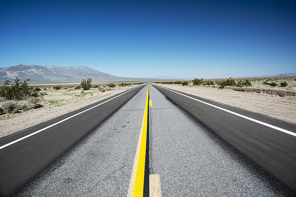
Looking north on California Highway 127 after leaving Baker. You probably think I cranked up the saturation on this photo, but I didn’t. The CalTrans folks had recently repainted the yellow and white lines. The dark blue skies are due to the polarizing filter I had on my 24-120 lens.
Shoshone
The first time I ever visited Shoshone was on the Destinations Deal ride. I remember well the terror I felt on that stretch of road, leading a group of other riders after a long day through Death Valley. We were heading south on Badwater Basin Road and I was relying on my cell phone and Waze to guide me. I was worried about running out of gas, keeping one eye on the gas gage and the other on the road. I should be okay, I kept thinking, but I’d never been this way before and I didn’t know. Then my Waze program quit. It had been running on stored info because I had no cell phone reception for the last 60 or 70 miles. The gas gage was nudging closer to the “no more” line and I was sweating bullets. It sure was remote out there.
Finally, Highway 178 ran into Highway 127 and a sign pointed to Shoshone. I felt better, and then I realized I didn’t have the Shoshone Inn’s address where we would spend the night. “How will I find it?” I wondered. It wouldn’t be easy leading other riders while looking for the place (I’ve had to do this on other rides). Then I was suddenly in Shoshone and I started to laugh. You can’t miss the Shoshone Inn. It’s one of only three or four buildings. I’d say Shoshone was a wide spot in the road, but California 127 was no wider there than it was anywhere else.
Shoshone was founded by Ralph Fairbanks in 1910; initially, it was primarily a mining town (old Ralph was a Death Valley prospector and entrepreneur). Charles Brown (yep, Charlie Brown) married Fairbanks’ daughter. Charlie and Stella moved away, but they returned in 1920 and further developed the town. Charlie became a California state senator and he turned ownership of Shoshone over to his son (who was also named Charles Brown). I guess you might say Shoshone is a Charlie Brown kind of place. I been there a few times, always looking for a girl named Lucy, but so far, I’ve had no luck.
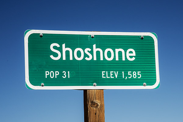
The sign lies.
As I mentioned in an earlier blog, the Population 31 sign lied. It’s only 13 people now. The lady who runs the hotel (Jennifer, not Lucy) commutes from Pahrump (Pahrump is about 45 minutes east on the other side of the Nevada state line). She told us about the sign lying. The rest of the people either died or moved away. None of them were named Lucy.
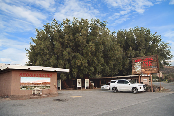
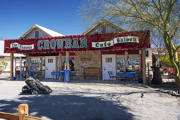
Shoshone is the last town before the southern entrance to Death Valley National Park. One woman, a Mrs. Sorrells, inherited the town. There’s a school that handles kids from K through 12th grade, some of whom commute from up to 120 miles away. There’s a general store (including a gas station), a museum, a restaurant (the Crowbar Cafe and Saloon), a nature trail, an RV park, and an unmanned airstrip. I guess if you are flying to Shoshone, you have to make a pass or two over the runway to make sure it’s clear.
The Shoshone Inn
A film photo taken with the Nikon N70 and tweaked in Photoshop.
The Shoshone Inn is surprisingly nice, although it’s probably time for it to be refurbished. There’s a gas-fired fire pit outside in the unpaved parking lot; when I rode into Shoshone with the Destinations Deal crew we spent a nice evening drinking Joe Gresh’s beer, which he bought from Shoshone’s next-door Charles Brown general store.
I got up early the next morning to take pictures with my film camera (the N70 my sister gave to me) and I saw that the fire pit was still going; I think the Shoshone Inn desk clerk may have forgotten to turn it off (they will be surprised when they get their gas bill).
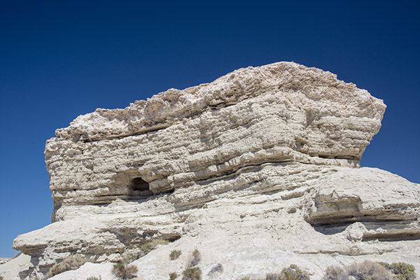
The Charlie Brown Rocks
A view of the Charlie Brown rocks.
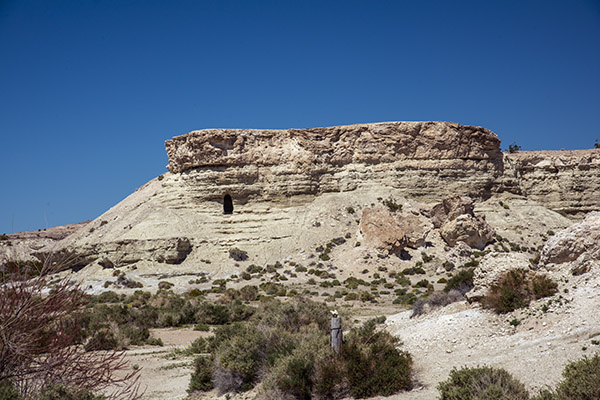
When I Googled what else was around Shoshone, the Charlie Brown rocks appeared. Highway 178 east intersects with Highway 127 right at the southern edge of Shoshone. When I saw the Charlie Brown rocks on Google, I wasn’t sure how far east on 178 I’d have to go, but when I approached Shoshone, I saw it was not far at all. The rocks are what appear to be sandstone formations and they are kind of in your face as you approach Shoshone. I could see the cave openings I’d read about, but there were signs to ward off trespassers and I didn’t want to wander in. A few photos were good enough.
A shot from Highway 178.
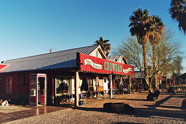
The Crowbar Cafe and Saloon
An N70 photo of the Crowbar Cafe and Saloon. It’s diagonally across the street from the Shoshone Inn.
Sue and I had two meals in the Crowbar. As I had experienced on previous visits (especially if you get there later in the day) it’s good to have three or four meal choices ready when the waitress takes your order. Hamburgers? No hamburgers, we had a busload of Chinese tourists come through and they ate all the hamburgers. Trout? No trout. Tacos? Yep, the Crowbar had tacos and they were surprisingly good.
The same restaurant, but with the D810 Nikon. Digital is superior to film. Duh.
When we left after lunch that first day, we spotted a small airplane on the runway at the town’s southern edge (the runway is tucked into the southeastern corner of the Highway 127/178 intersection). There’s no tower or buildings or anything else there, and you only see that it’s a paved runway when you look (you wouldn’t notice it otherwise). We think the four young guys who were sitting one table over from us at lunch flew in from somewhere to eat at the Crowbar.
We sat at the bar the next night and the one-man-band lady who handled everything (waitressing, barmaiding, dishwashing, etc.) asked if I wanted a beer. You bet, I answered. There were four taps, all unmarked. She didn’t know which tap had which beer, so she poured me a small sample of each and I opted for a craft-brewed dark beer. The bartender/waiter/dishwasher told me was made in nearby Tecopa. It was good, as were the chicken fajitas Sue and I shared for dinner.
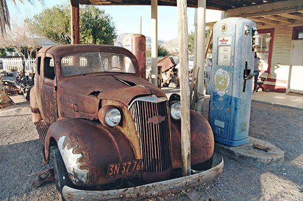
The Shoshone Museum
An N70 photo of the Museum. Not too bad for an old film camera.
We didn’t go into the Shoshone museum because it was closed the two times we visited the Crowbar (it’s right next door). It didn’t look as if there was much there; it was all housed in a very small building. I took a picture of an old Chevy, an old fuel pump, and a bit of junk in front of the museum. I’m guessing the museum used to be a gas station. I’ll bet Charlie Brown owned it.
Tecopa Springs
Tecopa Springs is short drive east of Shoshone on Highway 178. We went there twice. We saw quite a few RVs but we only saw a few people in front of Tecopa’s two restaurants. A young fellow we spoke to at the Crowbar the previous night told us he lived in Tecopa for six months each year and worked remotely (he was a digital nomad like Mike Huber). I imagine he spent winters in Tecopa and found someplace cooler in the summer. He said he came into Shoshone once a week for dinner because he wanted fried food and he couldn’t make fried food in his RV.
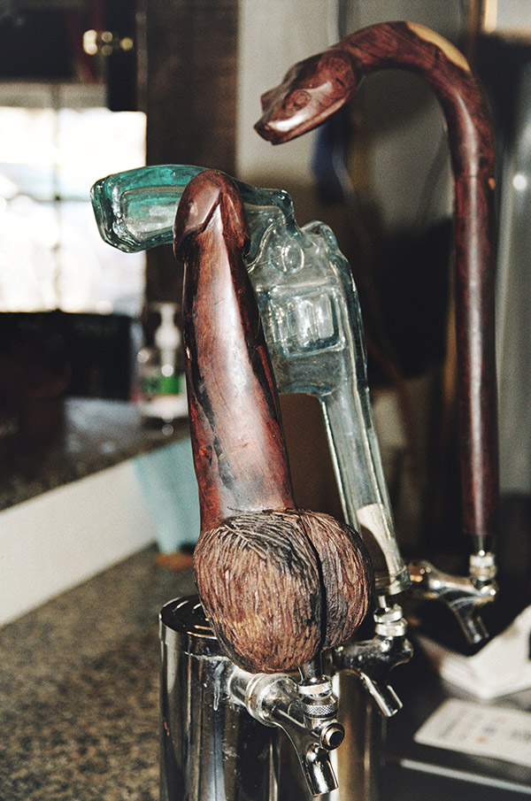
The two restaurants in Tecopa are a barbeque place and a combined bar and pizza place. The digital nomad we spoke with in the Crowbar said Wednesday (the day we rolled into Tecopa for dinner) was the best night at the barbeque place, but that restaurant was closed when we rode by. We rode on to the beer and pizza palace. When we entered, I asked the guy at the bar about the dark beer I’d had the night before in Shoshone (which was made in Tecopa), but they didn’t serve that brew there. He gave me a small sample of their dark beer (also brewed in Tecopa). It had kind of a peanut flavor to it and I thought it was okay, but the beer the previous night was better. The bar only had two seats; there were other people drinking and smoking at tables outside the restaurant.
What can I say? Folks in Tecopa don’t have a lot to do, I guess. This is an N70 photo.
When I asked about their dark beer, the one guy who was seated at the bar told me,”it’s this one…the dick.” I wasn’t sure I heard him correctly until I looked at the tap (which I hadn’t noticed). It was, indeed, a dick. I had to grab a photo.
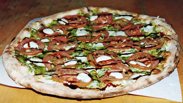
Tecopa pizza, via the N70. There’s a whole lotta PhotoShop tweakin’ goin’ on in this photo.
We ordered a pizza that seemed to take forever. When the guy finally brought it out, it was cold. It had probably sat for a while. Trust me on this: You wouldn’t want to make the trip to Tecopa for the pizza. Maybe the photo ops, but not the pizza.
There’s also a date farm somewhere beyond Tecopa. Sue and I rode out there after dinner, but it closed at 5:00 p.m. and we were too late. They had date shakes and I was looking forward to one, but that will have to wait until my next visit.
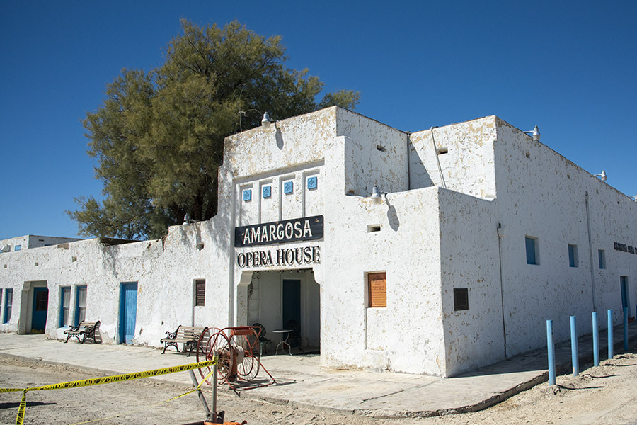
The Amargosa Opera House
After poking around a bit more on the Internet, I read about the Amargosa Opera House in Death Valley Junction. It was 50 miles north of Shoshone. The pictures on the Internet looked like the Opera House theatre’s interior would make for an interesting photo stop, so I called a couple of days before. I mentioned that I was doing this for the ExhaustNotes website and possibly, a travel article for Motorcycle Classics magazine.
My free photo. Saved $500 on that one, I did.
A young lady answered the phone and told me I needed to email their Director of Operations. She promised he would get back to me that day. That sounded like a plan and the Director of Operations did indeed get back to me with this message: I could take their daily tour (at a cost of $15 per person) or I could pay $500 for one hour to photograph the theatre. Gulp. I can’t remember ever paying anyone anything for something like this.
Sue and I rode to Death Valley Junction anyway, and I grabbed a few photos from the outside. When we first saw the place, it looked run down. It’s hard to believe anyone would stay their hotel, but I guess people do. A few photos and a $500 savings later, we were back on the road.
Pahrump
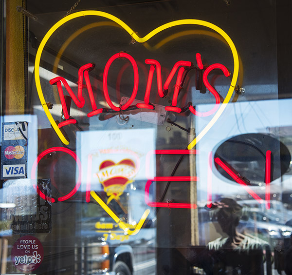
After spending another half day in Death Valley National Park, we decided to head over to Red Rock Canyon National Conservation Area. That’s near Las Vegas. On the way over, we crossed into Nevada and entered Pahrump. Pahrump is a much bigger town than anything around Death Valley. It has been one of the fastest growing towns in the entire U.S., with 15% year-over-year population growth for each of the last several years. We thought Pahrump would be a good place to have lunch, and we were right.
Mom’s: A great restaurant in Pahrump.
Sue found a place called Mom’s on her cell phone, it had great reviews, and we had to wait a few minutes to get in (which is always a good sign). Trust me on this: If you ever find yourself in Pahrump, Mom’s is where you want to eat.
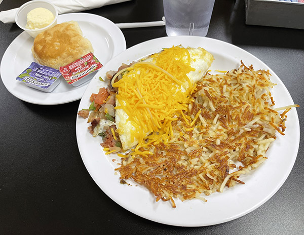
I had a corn beef hash omelet for lunch at Mom’s. It was magnificent.
As I mentioned above, we went through Pahrump on our way to the Red Rock Canyon National Conservation Area. I was going to squeeze that in here, too, but this blog is getting a little long. I’ll save Red Rock for another blog.
On the ride out of town on our way back to Shoshone, we stopped for gas in Pahrump. It was $3.68 per gallon. That’s a good two bucks cheaper than what we pay in California. After filling up and on the way out of town, we saw a gun store creatively named Pahrump Guns and Ammo. Sue won’t let me drive past a gun store without stopping, so we did. It was a small place and we had a nice visit with the two guys who worked there. I told them we were from California and we were collecting campaign contributions for Hillary Clinton. We had a good laugh. People in Pahrump have a sense of humor.
Barstow’s Del Taco Restaurants
You probably think I’m crazy including the Barstow Del Taco restaurants in this blog. I’m listing it here because if you’re going to Death Valley from southern California, it’s a safe bet you’re going to pass through Barstow, and if you’re going to pass through Barstow, you need to stop at one of the three Del Tacos there.
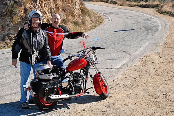
There’s a story behind this. About 15 years ago I had a bad motorcycle crash and I had to spend a month in the hospital. One of the guys I shared a room with was the son of Ed Hackbarth, the entrepreneur who founded the Del Taco restaurant chain.
One of the three Barstow Del Taco restaurants. Trust me on this: You want to stop at Del Taco in Barstow.
Ed Hackbarth is a real prince of a guy. He started Del Taco in Barstow, the restaurant chain was riotously successful, and it spread all over the U.S. Ed sold the Del Taco chain way back in 1976 to a group of investors and it continues to thrive. But there’s a big difference between the rest of the Del Taco empire and the three Del Tacos in Barstow. When Ed sold Del Taco, part of the deal was that he kept the original three Barstow Del Tacos. Ed would continue to use the Del Taco name on those three restaurants, but he didn’t have to use the Del Taco menu and he could serve food the way he wanted. And that’s what Ed does. The portions are bigger (they’re huge, actually), everything is fresh (nothing is ever frozen), the restaurants are immaculate, and the staff is super friendly. The Barstow Del Tacos have some of the best tacos and burritos I’ve ever had. We won’t drive through Barstow without stopping at one of Ed’s three Del Tacos, and there’s been times we’ve made the 80-mile trek from my home to Barstow just for a taco. You should try one. You can thank me later.
I guess I like Death Valley, because when Sue and I learned we had to use or lose some of our airline miles (and that we could use them for a hotel stay), we opted for a couple of nights at the Shoshone Inn in Shoshone, California (Shoshone is a little town just below Death Valley’s southern edge). Plus, I wanted to play with the N70 Nikon (a film camera) a little more and compare some of its photos to the digital pics from my Nikon D810.
The 2024 Death Valley Adventure Run route. We took a couple of days to do this and more. You could cram it all into a single day, but what be the point?
The plan was to roll in to Shoshone through Baker, and hit Dante’s View, Zabriskie Point, Artist’s Palette, Badwater Basin, the Ashford Mill ruins, and then head back to Shoshone. If we had enough time, we wanted to explore other points of interest, too.
When we checked in to the Shoshone Hotel on this visit, I asked about the 31 people who lived there. The hotel clerk told me the sign lied. The current population was 13 (not 31) people.
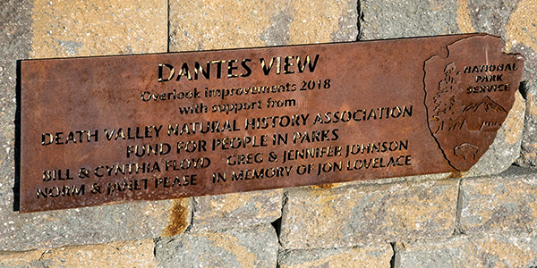
Dante’s View
The sign up at Dante’s View, nicely oxidized.
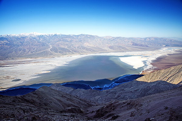
Our first stop the next morning was at Dante’s View. This spot gives a good overview of nearly the entire Death Valley basin and the surrounding mountains. Here’s the view looking northwest:
You can see that Death Valley was flooded, and that the floodwaters in the basin were receding. No kayaking allowed by the time we arrived.
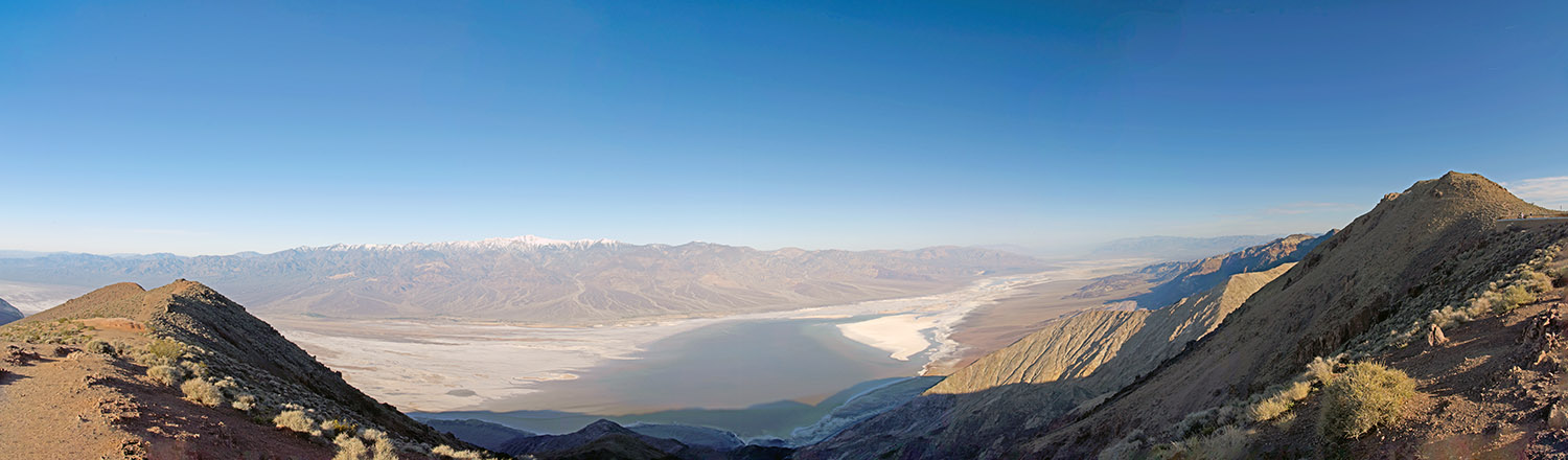
The vantage point at Dante’s View is really a panorama from nearly due north to nearly due south. I took several photographs from that vantage point and stitched them together in Photoshop. The photo below is a link. If you click on it, it will open a larger version.
Go ahead and click on this photo…I dare you.
Zabriskie Point
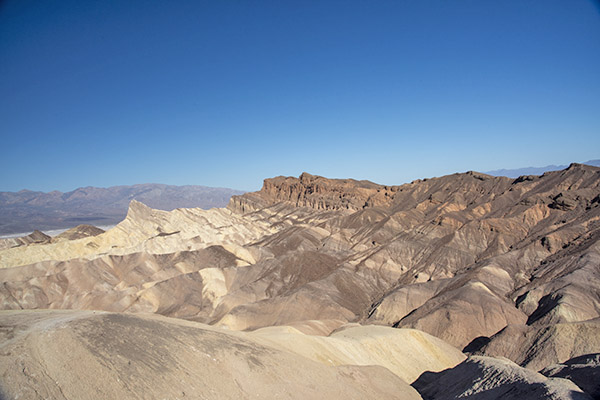
From there, it was on to Zabriskie Point. We backtracked from Dante’s View back to Highway 190, turned left, and then headed to Zabriskie Point. The ride through the rolling desert was nice, and the views were spectacular.
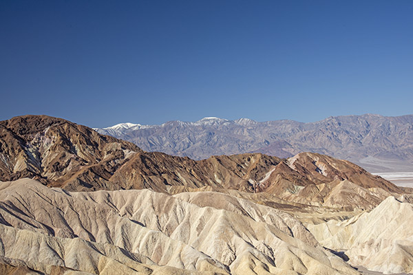
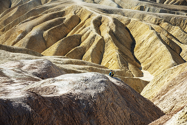
Walking up to Zabriskie Point. This is another scenic location, with lots of California and Death Valley geology on display.A view of the different strata at Zabriskie Point.Looking across Death Valley to the snow-capped mountains on the other side.Zabriskie Point badlands. You can have a lot of fun with a camera at Death Valley. This was a good time of year to be there, too.
Artist’s Palette
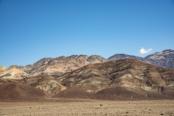
Artist’s Palette. There are different elements present in these mountains, which provide an array of color.
From there it was on to Artist’s Palette and then Badwater Basin. Artist’s Palette is a on a road that cuts off of Badwater Basin Road. The name is based on the fact that the hills in that area are multicolored. I plan to do another blog in the near future just on Artist’s Palette and the geology that gives the place its many hues.
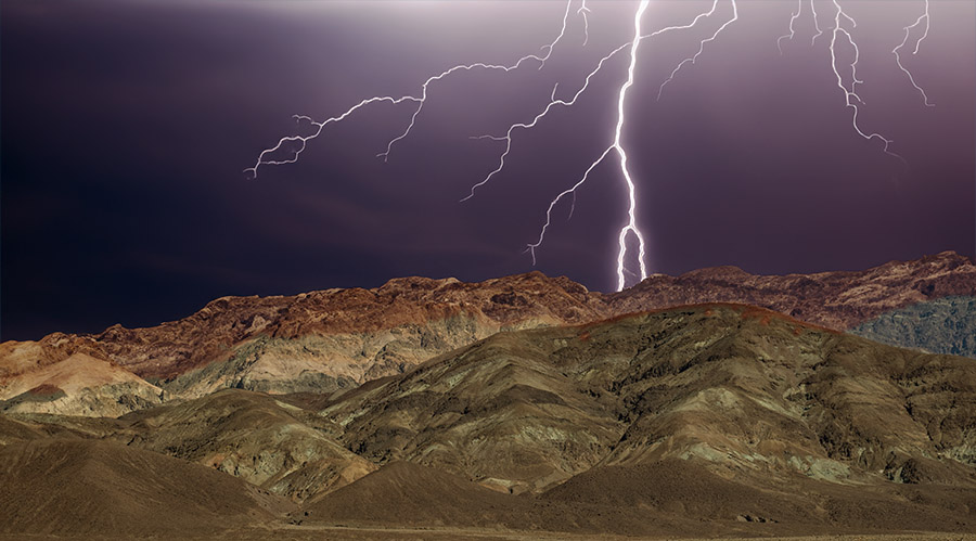
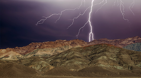
PhotoShop, artificial intelligence, fake lightning, and Artist’s Palette.
You might be wondering about the photo at the very top of this blog (I repeated here so you wouldn’t have to scroll up). No, I didn’t just happen to trip the D810 Nikon’s shutter when lightning struck. This is the same photograph of Artist’s Palette two pics up, but I had a little fun with a c0uple of PhotoShop features. I used the program’s artificial intelligence selection feature to select the sky (which, as you can see from the earlier photo was nice and sunny), and then I told PhotoShop to replace the sky with dark clouds and lightning. PhotoShop gave me three options; I selected the one you see here. What’s kind of cool is that it also shaded the mountains a bit, as they would appear under a dark and cloudy sky. I’m still on the fence on this topic of artificial intelligence and its uses. I’d prefer just plain old actual intelligence in more of my fellow mammals, but hey, I’m a grumpy old man who likes to shout at the clouds. What’s nice is now I can use AI to make the clouds appear whenever I want to.
Badwater Basin
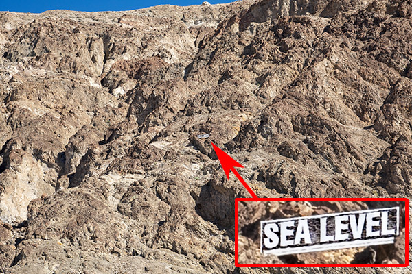
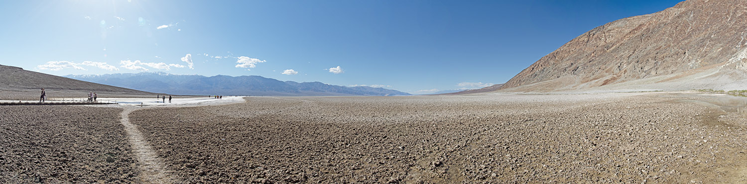
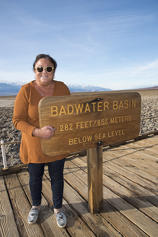
After Artist’s Palette, we were back on Badwater Basin Road, headed south to Badwater Basin. Death Valley, as most folks know, is below sea level. As you ride through different parts of Death Valley, there are signs showing how far you are below sea level. It’s cool. Badwater Basin is the lowest of the low at 282 feet below sea level.
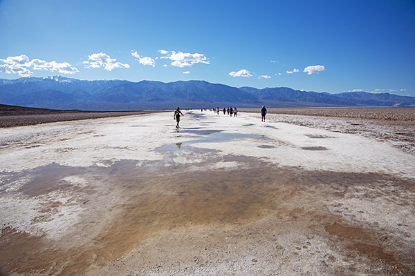
Looking up from Badwater Basin at the mountains to the east. Our location was 282 feet below sea level.Fellow tourists walking out into Death Valley’s Badwater Basin.
We had a lot of rain in southern California this winter, and in Death Valley, that resulted Badwater Basin being submerged. There was enough a couple of weeks before our visit that the National Park Service allowed kayaking in Badwater Basin. By the time of our visit, though, the Park authorities had put a lid on that. There was still water present, but it had receded enough that people would have to walk through the muck at the edges, which would damage the area. It’s too bad; a photo of folks kayaking in Badwater Basin would have been cool.
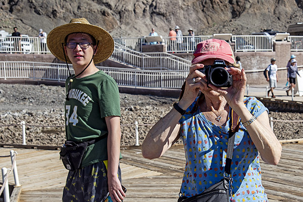
One of the nice things about traveling to places like Death Valley is that you meet people from all over the world. We had a nice conversation with a young guy from Beijing who was an exchange student in the Cal State system. I asked where he was from and he was hesitant to tell me at first, which I chalked up to nervousness induced by the tense(r) situation between the US and Chinese governments. I told him about our travels through China and that broke the ice. He was impressed.
Sue and I hamming it up with the cameras. The guy next to her is the young man from China mentioned above.
When you stand at the edge of Badwater Basin, there are mountains to the left and mountains to the right. I took nine photos and stitched them together in PhotoShop, just like I did for the Dante’s View panorama above. If you click on the photo below, it will open a larger version, which gives a small hint at the grandeur of the Badwater Basin vantage point.
Go ahead…make my day: Click on this photo.
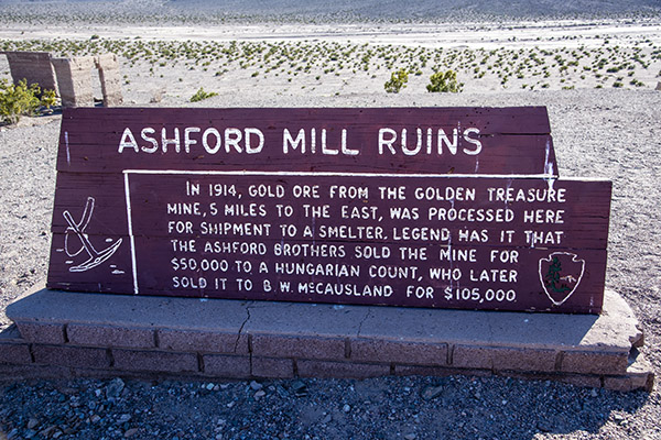
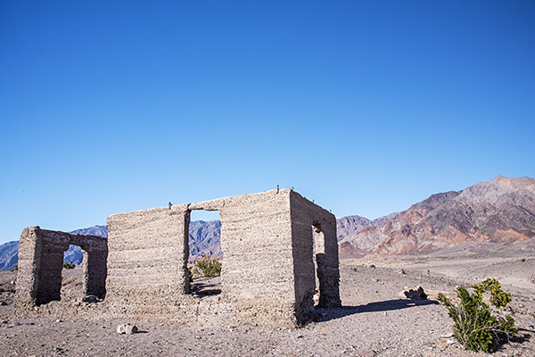
Ashford Mill Ruins
There’s not much to the Ashford Mill Ruins. It’s the shell of a building that processed gold prior to shipment out of Death Valley. It was on the road back to Shoshone, so we stopped to grab a few photos.
All you ever wanted to know about the Ashford Mill ruins.What’s left of the Ashford Mill. Working here in the summer must have been brutal.
We wrapped up our ride through Death Valley late in the day, continuing south on Badwater Basin Road and then east as it became Highway 178. It was back to Shoshone for us, with dinner that night in Tecopa Springs. I’ll tell you more about that hopping locale in the next blog.
As I mentioned in a recent blog, Sue and I recently spent a couple of days in Death Valley. I love the place. I lived in California for 30+ years before I ever made the trip out there on my KLR 650, and since then, I’ve been back several times. Here’s a short recap of those previous visits.
The Teutonic Twins Run
My KLR in Death Valley on that first visit. I loved my KLR; it was a great motorcycle.Good buddy Dennis, who won the chili-eating contest at Brown’s BMW.
That first ride on the KLR 650 didn’t just happen because I decided to finally get out there to see the hottest place on the planet. It came about because the guys at Brown BMW had a chili cookoff and eating contest followed by a two-day ride to Death Valley. If it hadn’t been for that, I wouldn’t have made it out there. I was the lone KLR rider; all the other guys were on big BMW twins. I’d ridden with those guys before and they were too fast for me. Nope, I was happy as a clam poking along on my 650cc single. I left right after the chili cookoff because I planned to meander along through other parts of the Mojave before spending the night in Baker, which was to be our jumping off point the next morning. It was fun, that ride out to Baker was. Just me and the KLR. I explored the desert around Kelbaker (southeast of Baker) and the old train depot there.
The next morning, we all had breakfast at the Mad Greek (a Baker and southern California icon), and then rolled out on California State Route 127 to the lower end of Death Valley. That’s a good highway that cuts through the desert. There’s nothing else out there, and the Teutonic twin crowd quickly left me in the dust. They were running well over 100 mph; the KLR might touch 100 on a good day. But I didn’t need to run at those speeds that day. I was enjoying the ride.
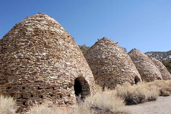
The charcoal kilns in Death Valley, I’m sure glad I didn’t skip seeing them on that first Death Valley foray.
When I left Death Valley on that first trip, I left through the northwestern part to pick up the 395 back down to southern California. That was a good thing. I saw a sign for Wildrose Canyon Road and another sign for the charcoal kilns pointing down a dirt road. I was by myself and I was in no hurry. I didn’t have any idea what the charcoal kilns were all about, but I was interested in learning more. I took that road, and I’m glad I did. Every time I’ve been in Death Valley since that first trip, the road to the charcoal kilns was closed, including on this my recent trip. If you are ever out there and the road is open, you might consider seeing them. The kilns are interesting, and Wildrose Canyon Road (as the name suggests) is a beautiful ride.
The Hell’s Loop Endurance Run
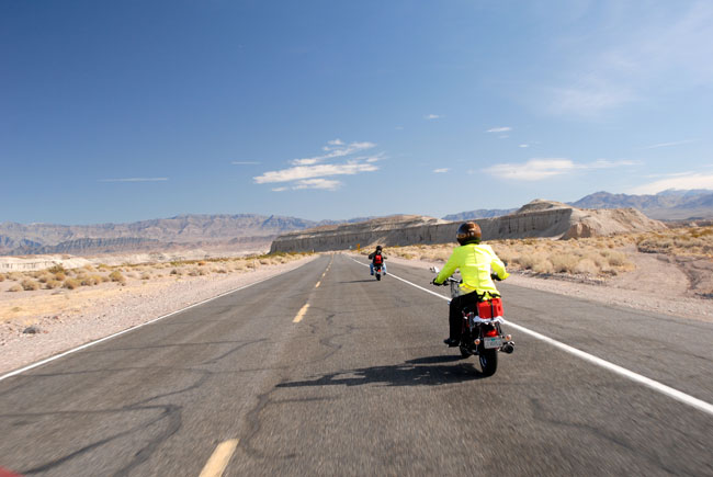
Following Arlene and TK on 150cc California Scooters into Death Valley.
Another ride in was when good buddy TK, good buddy Arlene, and I rode in the Hell’s Loop endurance rally on the 150cc California Scooters. That was a challenging day. We rode 400 miles into and through Death Valley and then returned to Barstow. It was cold and the hardtail CSC 150 beat me up, but it was fun. That little 150 never missed a beat.
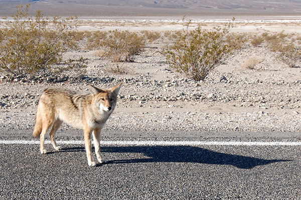
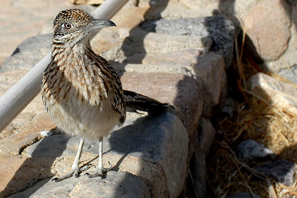
We had lunch at the Furnace Creek Inn, and shortly before turning off the road, we saw this guy. He is obviously well fed.As soon as we sat down for lunch at the Furnace Creek Inn, this guy landed a couple feet away. We had just seen the coyote. I asked the roadrunner if he owned anything made by Acme, or if he was being chased by old Wiley. He responded with but two words: Beep Beep.
My next Death Valley adventure was a photo safari with Sue. We did that one in my Subie CrossTrek in a single day. It was a long day, but the photo ops did not disappoint. What was kind of cool about that trip is that when we rode through Badwater Basin, we saw a coyote loping along the road headed north, and a short while later when we stopped at the Furnace Creek Inn, a roadrunner landed right next to us as we enjoyed lunch on the patio. Was the roadrunner running from the coyote? Cue in the Warner Brothers: Beep beep!
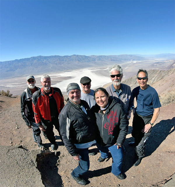
The Destinations Deal Tour
The Destinations Deal crew overlooking Death Valley from Dante’s View. We covered a lot of territory on that trip.
A few years ago we rode through Death Valley on RX3 motorcycles. That was part of a promotion we ran when I was working with CSC. We took a half dozen riders through a handful of southwestern states, and Death Valley was the last of several national park visits. It’s where I first met Orlando and his wife Velma. Joe Gresh was on that ride, too. It was fun.
The “My Sister Eileen” Trip
A 20-mule-team borax train.Just like the theatrical title: My sister Eileen. We had a great time on that trip.
After the Destinations Deal run, Sue and I and my sister Eileen had a road trip through California and Nevada, with a run down the 395 through a major league snowstorm. We went through Death Valley the next day (the snowstorm had ended) and it was awesome. I didn’t do a blog on that Death Valley visit (I have no idea why), but trust me on this: Like all trips to and through Death Valley, it was awesome.
That gets me caught up on my prior Death Valley visits. If you want to see more photos and read more about those earlier visits, here are the links:
Watch for a series of Death Valley blogs. The first will be about our most recent visit, and then I’ll post blogs about Death Valley history, Death Valley geology, things to do around Death Valley, Shoshone, nearby Red Rock Canyon National Park, and maybe more. Stay tuned.
Zongshen ended production of its iconic RX3 motorcycle and CSC sold the last of its RX3 inventory. I was tangentially involved in bringing the RX3 to America and I had a ton of fun on that motorcycle. Knowing that the RX3 is no longer in production is like hearing an old friend has passed away. In the end, the S-curve prevails for all of us, I guess. But it still hurts. The RX3 was and still is a great motorcycle.
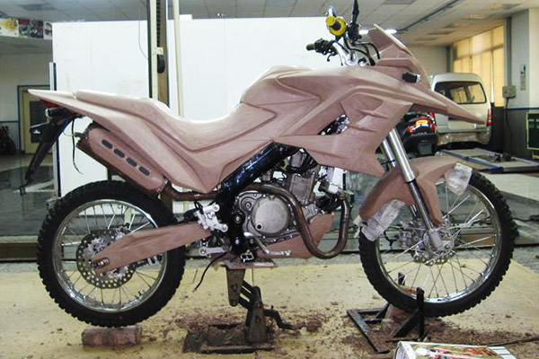
An early clay mockup of what would become the RX3 in Zongshen’s Advanced Design center.
According to my sources in Chongqing, Zongshen first started thinking about a 250cc offroad and adventure touring motorcycle in 2010. Engineering development took about two years (excluding the engine). China’s initial and traditional 250cc was based on a Honda CG125 air-cooled engine, which evolved into 150cc, 200cc, and 250cc variants (the 250cc CG engine was actually 223cc; it is the engine that powers CSC’s current TT 250). The CG-based variants didn’t have the performance Zongshen wanted for its new adventure touring motorcycle, and that led Zongshen to develop a 250cc water-cooled, four-valve engine for Megelli in Italy. It went into the Zongshen NC250 motorcycle. This engine also went into the RX3.
Yours truly with former Sears president and CSC advisor Carl Mungenast on Glendora Ridge Road. I rode the CSC 150 Mustang replica in this photo to Cabo San Lucas and back.
For CSC, the Zongshen connection started with a search for a larger CSC 150 engine. The CSC 150 was the Mustang replica Steve Seidner designed and manufactured in 2009. I was already in China for another client, and it was only an hour flight from Guangzhou to Chonqging for the initial visit to Zongshen. To make a long story slightly less long, CSC started purchasing the Zongshen 250cc engines for the little Mustangs. I think most of the folks who bought those Mustangs really didn’t care if it was a 150 or a 250. Both were capable bikes; my friends and I rode the 150cc version to Cabo and back. It was the 250cc Mustang engine that established the relationship between CSC and Zongshen, though, and that was a good thing.
When CSC’s Steve Seidner noticed an illustration of the RX3 on the Zongshen website, he immediately recognized the RX3 sales potential in the United States. Steve ordered three bikes for evaluation and he started the U.S. certification process. Steve and I did a 350-mile ride on two of those bikes through the southern California desert and we both thought they were great.
Showing the Zongshen execs in Chongqing possibilities for a ride in America. The Chinese sponsored the Western America Adventure Ride as a result of that discussion. It was awesome and the bikes performed magnificently.
Zongshen was not targeting the U.S. market when they developed the RX3; they thought the U.S. market had different requirements and consumer preferences. The initial RX3 design did not meet U.S. Department of Transportation lighting and other requirements. It was back to China for me to help set up the specs for the CSC RX3 and the initial order.
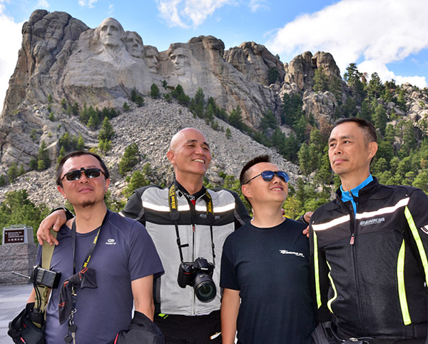
On the Western America Adventure Ride, we rode from southern California to Mt. Rushmore, back to the Pacific across the top of America, and down the Pacific Coast to return to Azusa. Here King Kong, Leonard, Hugo, and Tso emulate the American presidents at Mt. Rushmore.
On that early visit, the Chinese told me they wanted to ride in America. They sent over a dozen bikes and as many riders, and we had an amazing 5,000-mile adventure we called the Western America Adventure Ride. Baja John planned the itinerary and mapped out the entire ride; we even had special decals with our route outlined made up for the bikes. We let the media know about it and it was on this ride that I first met Joe Gresh, who wrote the “Cranked” column for Motorcyclist magazine. I made a lot of good friends on that trip. After the trip through the American Southwest, Zongshen invited Gresh and me on a ride around China, and after that, I was invited by AKT on a ride through the Andes Mountains in Colombia.
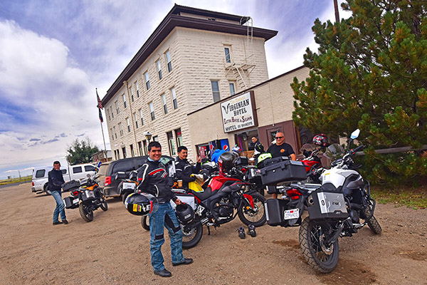
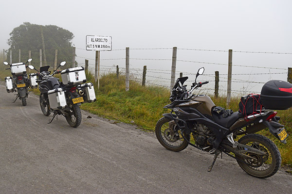
In Medicine Bow, Wyoming, on the Western America Adventure Ride. Two Colombians also participated, which resulted in an invitation to ride in Colombia.On the road in the Andes Mountains. The sign says the elevation is 3950 meters (that’s 13,000 feet above sea level).Joe Gresh and I gladiating near Liqian, China. The China ride was the adventure of a lifetime.
At CSC, we had a lot of discussions on the initial marketing approach. We were looking at a $50,000 to $100,000 hit for an advertising campaign. Maureen Seidner, the chief marketing strategist for CSC and co-owner with Steve, had a better idea: Sell the bikes at a loss initially, get them out in the market, and let the word spread naturally. We knew the price would stabilize somewhere above $4K; Steve’s concept was to sell the bike for $2995. Maureen had an even better idea. $2995 sounded like we were just futzing the number to get it below $3K; Maureen said let’s make it $2895 for the first shipment instead. I wrote a CSC blog about the RX3 and CSC’s plans to import the bike. When I hit the Publish button on WordPress for that blog, the phone rang literally two minutes later and I took the first order from a guy in Alaska. Sales took off with CSC’s introductory “Don’t Miss The Boat” marketing program.
I wrote another CSC blog a week later saying that I was eager to get my RX3 and ride it through Baja. I thought then (and I still think now) that the RX3 is the perfect bike for Baja. The bike does 80mph, it gets 70mpg, it has a 4-gallon gas tank, and everything you needed on an ADV touring machine was already there: A skid plate, good range, good speeds, a six-speed gearbox, a comfortable ride, the ability to ride on dirt roads, panniers, a top case, and more. We started getting calls from folks wanting to ride with me in Baja, and the orders continued to pile in. That resulted in our doing an annual run through Baja for RX3 owners. We didn’t charge anything for the Baja trips. It was a hell of a deal that continued for the next four or five years. I had a lot of fun on those trips and we sold a lot of bikes as a result.
The Western America Adventure Riders in Arizona. This photo is prominently displayed in the Zongshen main office building lobby. That’s Baja John in front; he did nearly all the work organizing the ride.
CSC’s enthusiasm surrounding the RX3, the CSC company rides, and CSC’s online presence did a lot to promote the RX3 worldwide, and I know Zongshen recognized that. I visited the Zongshen campus in Chongqing several times. One of the best parts of any Zongshen visit for me was entering their headquarters, where a 10-foot-wide photo of the Western America Adventure Ride participants in Arizona’s red rock country dominated the lobby.
The RX3 was controversial for some. RX3 owners loved the bike. A few others found reasons to hate it, mostly centering around the engine size and the fact that the bike came from China. I spent a lot of time responding to negative Internet comments until I realized that the haters were broken people, there was no reasoning with them, and none were ever actually going to buy the motorcycle anyway. These were people who got their rocks off by throwing rocks at others.
When RX3 production ended recently, I contacted one of my friends at Zongshen and I thought you might enjoy some of what he told me. Zongshen sold 74,100 RX3 motorcycles (35,000 in China; the rest went to other countries including Mexico, Colombia, other South American countries, Singapore, Turkey, and the United States). Colombia alone purchased 6000 units in kit form and assembled their bikes in Medellin. I watched RX3 motorcycles being built in the Zongshen plant in Chongqing; I was also in the AKT factory in Colombia and I saw the RS3 (the carbureted version of the RX3) being built there. Ultimately, RX3 demand dropped off, but 74,100 motorcycles is not a number to sneeze at. The RX3 greatly exceeded Zongshen’s expectations and their initial marketing forecasts, especially in overseas markets. CSC had a lot to do with that success, and playing a minor role in that endeavor has been one of the high points of my life.
The CSC 650cc RX6 twin cylinder motorcycle. The Chinese motorcycle industry is moving to larger displacement bikes.
Chinese motorcycle companies today are emphasizing larger bikes. We’ve seen that here with the CSC RX4, the 400cc twins, and the 650cc RX6. I’ve ridden all those bikes and they are great. I like larger bikes, but I still think a 250cc motorcycle is the perfect size for real world adventure riding. I think the emphasis on larger bikes and the decision to drop the RX3 is a mistake, but I haven’t sold millions of motorcycles (and Zongshen, with CSC’s help, has).
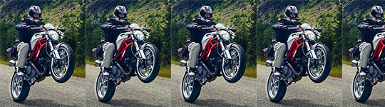
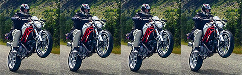
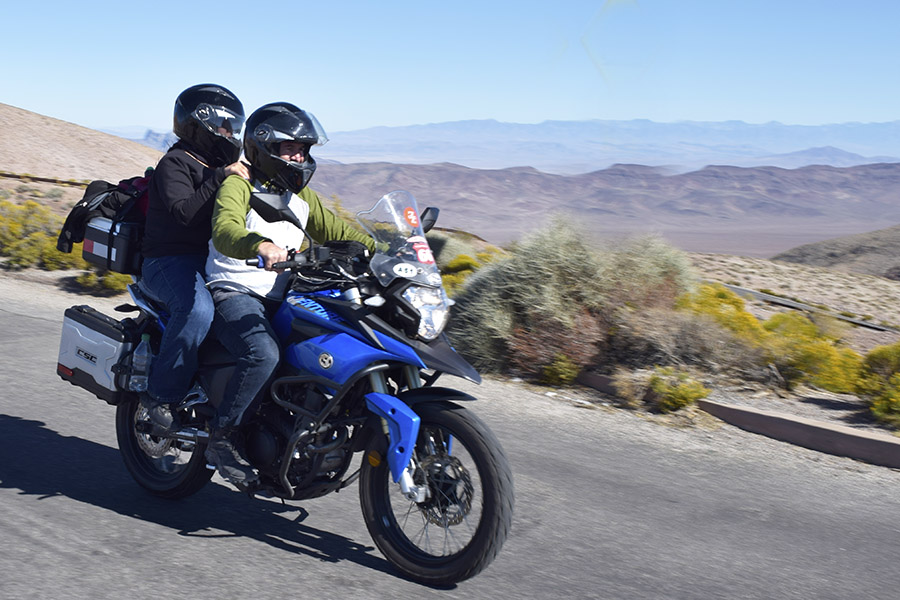
That photo you see above at the top of this blog? It’s good buddy Orlando and his wife Velma riding their RX3 up to Dante’s View in Death Valley National Park. Orlando thinks blue is the fastest color, but I know orange is. Sue and I recently visited Death Valley again; watch for the ride reports here on the ExNotes blog.
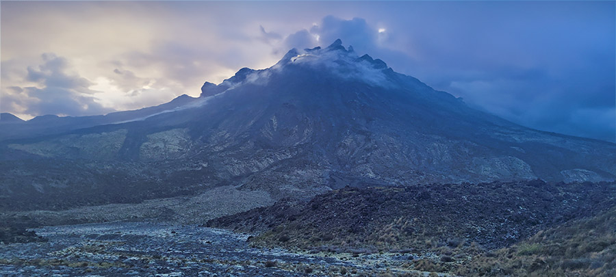
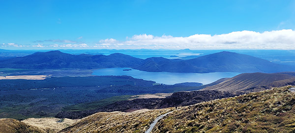
The Tongariro Crossing in New Zealand is touted as one of the world’s best day hikes. This obviously meant it was a hike I had to tackle. The crossing is 19.4 kilometers (11.64 miles) across an active volcano, and it includes a LOT of stairs, both up and down. Having not been hiking in several months, this was the first time I was actually questioning my physical ability. I don’t think it comes from age as much as hard landings from falling out of airplanes. Either way, it’s the Number 1 hike on Earth so it really needed to be checked off my list.
As with all mountains, the weather is constantly changing and this mountain would prove no different. The previous day the hikes were cancelled due to heavy winds. Upon waking up at 0400 it was a relief to learn that the shuttles would be running that day. My campsite was just outside the town of National Park and was right along the shuttle path for a 0545 pickup and a 30-minute drive to the trailhead.
The hike started with misty clouds which added to the already stunning mountain scenery, and the winds, well they were blowing hard. I had purposely loaded my day pack heavy with extra everything in the event I’d need it. That was smart. By day’s end I had used almost everything I brought. This was comforting since I thought I had over packed.
The first five kilometers weren’t bad except for the brutal winds, which were a constant battle. It got to the point that when the winds subsided I’d almost fall down due to leaning in so much. Once that five kilometers were wrapping up, there were several posted signs that said “If you aren’t feeling well, now is a great time to turn back, there is no shame in that.” I used those signs as motivation to continue.
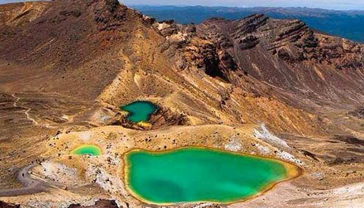
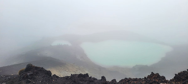
Once reaching the summit, it was obvious the crown jewel of the hike would not be shining as brightly as it had been in the photos. There were two bright neon emerald green lakes that in the sun just glowed; however, with the weather having turned so quickly it was nothing more than a dull blue barely visible through the cloud bank. The winds were still howling from every direction. There was hardly even time to snap a few photos before I decided it was time to descend into the next crater for some shelter and to take a break and eat a snack. The only portion that remained was the never-ending descent filled with many more steps.
Overall, it was a magnificent day with great views and conversation with fellow hikers from all over the world. My finish time, not that it matters, was just over 6 hours. This seemed admirable as the estimated time for most was between 6 and 8 hours. The remainder of the day was spent at my campsite swimming in my own personal grotto behind my tent, talking with others that hiked it (or would in the morning), consuming ibuprofen, and feeling semi accomplished now that this hike was now completed.
California is beautiful from every aspect, but once you climb on a motorcycle and get the full experience of this gorgeous state you’ll realize it is difficult to find a place with more riding diversity. From the northern redwoods to the people-watching along Venice beach to the eastern deserts and right up to the Sierras. California is a destination where you’ll want to spend time. And when I say time, I mean having the ability to savor each region and each road.
Garberville to Fort Bragg
Rated 5 Wheelies
Route Details. This is a beautiful road with twisties that rival the famous Tail of the Dragon in North Carolina, with much more diversity due to the forest and ocean views.
Start and Finish Points: Garberville to Ft. Bragg
Distance: 68 miles
Ride Time / Recommended Time: 3-4 hours
Recommended Time of Year: May-Oct
Main Points of Interest(s): The stretch from Leggett to Rockport
Cautions / Dangers: Minimal but possible sand/rocks on road in mountain twisties
Important Contact Numbers CHP (Ukiah) 707- 467-4420
Road Description. I chose this route as my #1 in California due to the technical street riding, lack of traffic, and scenery. This route also has plenty of classic Americana stops along the way that even for this short ride will add to the enrichment of this route. It is an out of this world experience and you will feel at times as if you are in Star Wars zooming through Endor on a speeder. Once you adapt to that environment you are thrust out of the forest and into views of the vast openness of the mighty Pacific Ocean. It is hard to achieve a greater riding experience from every aspect over such a short distance.
Points of Interest. Garberville is a wonderful place to start as it is a quaint little hidden California town with wonderful people. The people are down to earth and easy to talk with as you consume a cold beverage or lunch while comparing tales from the road. There aren’t a lot of restaurants or stores in Garberville but the two I recommend are:
The Blue Room (747 Redwood Drive in Garberville, a great place for a drink/lunch/dinner)
The Eel Café (801 Redwood Drive, which offers breakfast and lunch sandwiches)
Another must see spot is the Drive Thru Tree Park for an unforgettable experience and great photo opportunities. Make sure you drive your moto through the Redwood tree.
Fort Bragg is larger compared to Garberville and offers more choices for nightlife and entertainment. Two of my favorites are:
The Tip Top Lounge, a great place to stop after riding all day for a beer and a solid burge
The Piaci Pub & Pizzaria for great pizzas and an environment conducive to unwinding
Where to Stay/Camp. Both Garberville and Fort Bragg offer numerous hotels and camping spots, and even though this is a short ride I highly recommend making this trip an overnighter to fully absorb the culture of this part of the state and its beauty. These are my favorite spots:
Santa Monica to Oxnard on the Pacific Coast Highway
Rated 5 Wheelies
Route Details. This is the quintessential California beach road with exhilarating sweeping corners that introduce a new view of the Pacific Ocean as you lean through each turn.
Start and Finish Points: Santa Monica to Oxnard
Distance: 50 miles
Ride Time/Recommended Time: 3 to 4 hours
Recommended Time of Year: April to November
Main Points Of Interest: Beaches along the route
Cautions / Dangers: Minimal, but possible sand near beaches
Important Contact Number: CHP (Woodland Hills) 818-888-0980
Road Description. As far as a California dream road, this is the one. Riding it early morning can be the best time due to low traffic and the ability to taste the salt from the Pacific Ocean as you wind northbound. There are plenty of beaches and overlooks to stop at. This really allows yourself to fully absorb the beauty of this part of California.
Points of Interest. Santa Monica is a great starting (or ending) point and you can walk out to the pier or rent bicycles to ride the boardwalk down to Venice Beach which will allow for some outstanding people watching and opportunities to engage in tourist attractions along the way. As you travel north from Santa Monica there are no shortage of quaint restaurants and shops along PCH1 to visit and relax. This is a road that feels as though it’s designed for a leisurely ride in order to fully experience the sights and sounds while on two wheels. A classic place to get some seafood is Neptune’s Net right along the Pacific Coast Highway for great seafood and wonderful people. If time allows, a worthwhile day can be spent visiting Channel Islands National Park.
Where to Stay/Camp. Camping is limited along this route but Point Mugu State Park is a great place for beach camping. Hotels are plentiful but expensive in both Santa Monica and Oxnard.
Highway 120 and Tioga Pass
Rated 5 Wheelies
Route Details. This is one of the best roads in California. It runs through Yosemite National Park and over intense switchbacks to Tioga Pass, where you will feel as though you are on top of the world (at almost 10,000 feet elevation, that isn’t too far from the truth). There are minimal fuel stops along this way so make sure you are fueled up.
Start and Finish Points: Groveland to Lee Vining
Distance: 92 miles
Ride Time / Recommended Time: 4 to 6 hours
Recommended Time of Year: May-September
Main Points Of Interest: Yosemite National Park and Tioga Pass (elevation 9,943 feet)
Cautions/Dangers: Wildlife throughout the passes, loose rocks and dirt on some mountain passes
Important Contact Number: CHP (Bridgeport) 760-932-7995
Road Description. Some incredible scenery as you pass through Yosemite National Park and even more breathtaking as you lean into some of the tightest switchbacks you can ever hope to encounter with serious drop offs so be sure to not get too caught up in the scenery and maintain focus on the road.
Points of Interest. Although this area of California is not as populated as some of the others there are plenty of places to stop and eat. With Yosemite National Park as the centerpiece of this ride there is a plethora of beauty and experiences to be had. My favorites are:
The Iron Door Saloon in Groveland as a perfect place to discuss your ride there or the one you are about to do
The Epic Café in Lee Vining for great breakfasts or lunches, or just to break up the day
Where to Stay/Camp. There are numerous inns, hotels, and quaint bed and breakfasts along this route. All the ones I experienced have been wonderful experiences. Here are two of my favorites on each side of the route, and the camping opportunities within Yosemite.
Lakeview Lodge in Lee Vining is a clean safe place to stay with modest rates and parking for your motorcycles
The Sonora Inn in Groveland is another winner both from a price standpoint and for the quality and cleanliness of the rooms
Cotton Springs Road to Joshua Tree
Rated 4.5 Wheelies
Route Details. A short but deeply satisfying route that winds through Joshua Tree National Park. No services along this way so be sure you fill your tank either east on I-10 at the Chevron Station or in the town of Joshua Tree (depending on which way you are traveling). Ensure you have water and are hydrated due to excessive heat during hotter times of the year.
Start and Finish Points: Exit 173 off I-10 to Joshua Tree
Distance: 94 miles
Ride Time/Recommended Time: 4 to 6 hours
Recommended Time of Year: September to November, February to May
Main Point Of Interest(s): Joshua Tree National Park
Cautions/Dangers: Loose rocks/dirt on some corners
Important Contact Number: CHP (29 Palms) 760-366-3707
Road Description. Beautiful desert and mountain views. In spring there are fields of wildflowers that really show how much life is in the fragile ecosystem of Joshua Tree. The roads are in excellent condition and encompass fun sweeping corners then will open up with straightaways that provide majestic vistas of the region.
Points of Interest. This is a desolate road, which is great for riders looking to just check out of the crowds and embrace riding. As previously stated there are no gas stations in the park so ensure you fill up prior to entering it.
Chevron off Exit 173 along Interstate 10 (62450 Chiriaco Road, Chiriaco Summit, California 92201)
In included the added mileage here through Joshua Tree National Park to allow you to fully explore the park (including the ride out and back to Keys View
For a great diner to fuel up before or after your ride try the Country Kitchen restaurant
Where to Stay/Camp. With Joshua Tree National Park being so desolate, camping there is a magical experience. On a clear night you can see the stars and planets like nowhere else. The campgrounds tend to fill up during peak seasons so be sure to reserve a campsite prior to your trip. As far as hotels go, both the town of Twenty Nine Palms and Joshua Tree have numerous hotels that are perfect for unwinding after the ride.
The Joshua Tree Inn is a great spot to relax with a pool and air conditioning after a hot ride through the park
Mulholland Highway
Rated 4 Wheelies
Route Details. This is a 50-mile route that is beyond filled with some serious mountain switchbacks. This is an incredibly intense road that to me rivals the Tail of the Dragon in NC. The switchbacks just don’t end as you climb through the Santa Monica Mountains and then spit out onto Highway 1 and views of the Pacific Ocean. It is a motorcyclist’s dream ride.
Start and Finish Points: Alizondo Drive Park to El Matador Beach
Distance: 50 miles
Ride Time / Recommended Time: 2 to 4 hours
Recommended Time of Year: Year round
Main Point Of Interest(s): The Rock Shop
Cautions / Dangers: Speed Traps
Important Contact Number: CHP (Woodland Hills) 818-888-0980
Road Description. For being so near to Los Angeles this road is a real getaway without having to travel far. The quality of the road is perfection and something that people from all over the LA area flock to. For this reason be cautious with your speed as there are several places they set up speed traps, however, quite often fellow riders will park ahead of these speed traps and provide you a warning. If you are looking at getting rid of the chicken strips on your tires this is definitely the road where you can accomplish that.
Points of Interest. This road has minimal places to stop along the way, but with all these switchbacks why would you want to stop. There is one famous attraction that is a must do as you traverse these mountain roads, and it is The Rock Store. It is a popular place for riders of all types to stop and get a sandwich and a drink. Jay Leno is often seen here talking shop with the riders and being social with others riding this fantastic road.
Where to Stay/Camp. With this ride being so close to the city there are minimal camping options. Hotels are numerous on both sides of this ride however. There are plenty of canyon roads off the main highway that are worth exploring, so even though this is a shorter ride you can absolutely make a full day out of this area. This will allow you time to fully embrace the roads and fellow riders along the way. My favorite place to camp is the Decker Canyon Camp.


 As with all mountains, the weather is constantly changing and this mountain would prove no different. The previous day the hikes were cancelled due to heavy winds. Upon waking up at 0400 it was a relief to learn that the shuttles would be running that day. My campsite was just outside the town of National Park and was right along the shuttle path for a 0545 pickup and a 30-minute drive to the trailhead.