The Top Five Southern Colorado Motorcycle Roads

By Mike Huber

As an avid motorcyclist it’s easy to appreciate the beauty in each state and for many riders discovering amazing roads that many would overlook can become second nature to us.  Some might even say it’s an art form.  Throughout this vast and beautiful country called the United States of America we are fortunate enough to have a plethora of both paved and dirt roads that are meant to be sought out like the Ark of the Covenant.  These roads are meant to be experienced intimately the only way they can be, on two wheels. Experiencing them on a motorcycle can become a thirst that is never quenched, and although each state has its own unique characteristics, ultimately some will stand out more than others. One state that has that effect for me is Colorado.

Colorado is one of those states that as soon as you ride past the “Welcome to Colorful Colorado” sign the roads seem to present themselves to you like a feast on a golden platter with an endless amount of wine.   The rides we will review can each be completed in one or two days and are best ridden between late April and early October.  To help with prioritization since there are so many incredible rides we have developed a very complex mathematical rating system of 1 to 5 wheelies (5 being the highest).  The rating uses the following criteria:

    • Road conditions
    • Diversity of riding options
    • Activities along the route
    • Abilities to disperse camp/hotel access
    • Scenery

Route 550:  The Million Dollar Highway

Rated 5 Wheelies

Road Description.  This loop may be one of the greatest roads in all of North America. The road is paved and in immaculate condition.  It combines some of the tightest switchbacks one can expect to experience on a motorcycle. The full route per the map is ~355 miles and can be done in 1 day, but highly recommend taking at least 2-4 to fully experience and immerse yourself in this beautiful part of the country.  There are endless forest roads off 550 to get your fill of dirt riding littered with an infinite amount of beautiful dispersed campsites. Also some wonderful old mining towns rich with history, hiking, restaurants, hotels, and hot springs.

Points of Interest.  There’s no shortage of amazing places to stop along this road.  Below is a small list of the places you should not miss along this route.

    • Silverton is a great little mining town with wonderful people.  It’s a perfect place to load up on supplies if you are camping.  You can warm up after getting some miles in at the Brown Bear Café.
    • Ouray is a beautiful mountain town with several hikes to waterfalls, hot springs, and some wonderful restaurants. My favorite is the Ouray Brewery.
    • Rico is a really tiny town which consists of a great hotel and bar called the Enterprise Bar and Grill, with wonderful people, great food and cold beer.

Where to Stay/Camp.  There is an immense amount of national forest land that can be used to camp on along this loop.  Really any dirt road you ride down will guide you to an epic campsite next to a creek. This makes for a relaxing post ride time to wind down in a hammock, while having a refreshing beverage. The towns of Silverton and Ouray have several hotels that are right in the heart of the town and a short walk to tourist activities and restaurants.

Off-Roading.  There is an endless amount of dirt roads to find here, this goes from flat well-groomed forest roads to find a campsite to the technical challenging mountain passes like Engineer or Imogene Pass (which I have not done due to the size of my GS1200 and conservative riding style).

Out of so many outstanding rides in the state of Colorado, the Million Dollar Highway should be on the top of any list.  This road and area really earn that 5 Wheelie rating due to exceeding each standard for riders of all ability levels. There are so many sights to see along this route that you will never tire of absorbing the beauty that surrounds you in this part of the state. If you are fortunate enough to have the time, doing the loop in reverse can be a great way to add a few more days to your adventure.

Mesa Verde National Park

Rated 5 Wheelies

Road Description.  As soon as you enter Mesa Verde National Park the road begins screaming up in elevation with some incredible views overlooking the valley below you will almost have a sense of vertigo overcome you.  What is wonderful about this feeling as it goes on and on as you travel through the park.  Although the distance from the park entrance to the furthest point is only 28 miles, those miles are filled with numerous overlooks and pullouts that can make this seemingly short ride take 2-3 days.  This is especially true if you are taking in the hikes along the way.  The only piece of concern for this ride is the numerous road snakes in some areas of this ride. Otherwise its full enjoyment as you have a 360 view of the valleys below that outstretch clear into Utah, New Mexico, and Arizona.

Points of Interest.  Since this is a National Park there are ample amounts of short hikes and tours to break up the day(s) you spend in this magical location. A few of the more popular ones are outlined below:

    • The Cliff Palace requires purchasing a tour ticket at Park Visitor Center, but even without one you can walk to the overlook to get a spectacular view of the houses the Hopi built into the cliffs which are all but hidden except from this vantage point.
    • The Balcony House also requires a tour ticket but is well worth it as you can walk through the ruins and really get a sense of the
    • The Knife’s Edge Hike is a great 2-mile hike with little elevation next to Morefield Campground that has incredible sunset views, which enable the rocks to really light up and glow.

Where to Stay/Camp.  Morefield Campground- This is the only campground in the park so making reservations ahead of time is recommended. It is one of the better National Park campgrounds I have stayed at and includes free showers, great Wi-Fi from most campsites (antennas are off the bathrooms), and a launderette, gas, and fully stocked store for all your camping and souvenir needs. There are also several wonderful hiking trails right next to the campground.

Off-Roading.  This is one of the drawbacks of a National Park, as there is no off-roading permitted within the park boundaries.  The beauty and activities from hiking and riding makes up for this shortcoming.

Route 65: Grand Mesa Scenic Byway

Rated 5 Wheelies

Road Description.  Yet another beautiful Colorado mountain road filled with switchbacks that rise in elevation and bring you to over 10,000 feet up and onto the World’s largest Mesa. There are several pullouts along this route to take in the views, but no gas stations from Cedaredge to Mesa (50 miles, but can be close to 100 miles if you are doing the off-road portion) plan accordingly.

Points of Interest. The main point of interest the mesa itself and the amazing views, alpine lakes, dispersed camping, and off-roading.

Where to Stay/Camp. Dispersed camping is plentiful along Rte125 where you can get a lakeside campsite with little issue and make it your own paradise for the evening as you watch the sunset glistening off one of the many alpine lakes. There are also plenty of campgrounds along this way if you are looking for less primitive camping.  Hotels are scattered along this route in the towns of Delta, Mesa, or driving to up Grand Junction for a greater variety of lodging.

Off-Roading.  Route 125 Surface Creek Road is a great 15-mile loop.  This road has you experience the mesa while passing crystal clear alpine lakes with numerous dispersed camping areas.  There is also a 10-mile dirt road in great condition to visit the Lands’ End Observatory. The views off the mesa looking down on the plateau can allow you to see into Utah on a clear day with awe inspiring views.

Route 141: Grand Junction to Naturita

Rated 4.5 Wheelies

Road Description.  This is a low elevation beautifully paved road that is 105 miles long.  This road will have you leaning your ride until you feel the mist kissing your windshield from Dolores River as you pass amazing rust colored mesas that stretch into the sky and rival that of Monument Valley. The road has very little traffic which will allow you to enjoy some solitude as you embrace the scenery you ride through. The only reason this route is rated as 4.5 is the lack of amenities.

Points of Interest.  This road is in quite a desolate area, outside the tiny town of Gateway.  Gateway Canyons General Store is owned and run by the preacher of the church next door to it.  This is the only place to gas up between Grand Junction and Naturita so be sure to check your fuel levels.

Where to Stay/Camp.  Dispersed camping here is plentiful but mainly in one area just south of Grand Junction, Divide Road. This road is a steep switchback dirt road that connects to numerous other roads which are great fun exploring for campsites to settle down in.  There are numerous dispersed sites with beautiful views over the canyon in which you can see the Dolores River running far beneath you.

Off-Roading.  Divide Road also encompasses numerous off-roading opportunities that sprawl out across this mesa.  This is a perfect place to explore for that unique dispersed campsite while hitting some fun dirt to enhance your day.  There are however areas of slippery clay, so if it is raining it can become slick in portions of this road.

Routes 160 and 149: Pagosa Springs to Lake City

Rated 4 Wheelies

Road Description.  This route consists of 45 miles of a four-lane highway on Route 160 that will have you summit at over 10,000 feet.  The road will then drop you into South Fork, Colorado.  This is where you will turn left onto Route 149.  Route 149 will quickly whittle down to a tighter and quieter road for the next 75 miles, which are filled with mountain passes. South Fork is the only town between these areas so make sure you gas up and grab lunch before heading onto the second part of this amazing road.  The next portion will have you speeding across lower elevation prairies and then climbing high into the mountain tundra that will resemble something from another planet before descending into Lake City.

Points of Interest.  I specifically wanted this trip to begin (or end) in Pagosa Springs so you have an opportunity to experience the hot springs in Pagosa.

Where to Stay/Camp. Throughout the ride there is no shortage of camping in both dispersed and paid locations. In Pagosa there are numerous hotels. I prefer the hotel directly across the street from the spa as it is much more affordable then the spa and in a great location.  For Lake City, the Matterhorn is a beautiful Swiss style motel which will allow you a solid night’s sleep at a great price. It’s a perfect spot to recharge if you are going to take on some of the more challenging off-road portions in Colorado the following day.

Off-Roading.  Lake City is the starting point for some of the more serious off-roading mountain passes, such as a few of the most popular passes including Cinnamon and Engineer.  Both of these passes surpass 12,000 feet.  If you crave technical off-roading challenges with views that can’t be beat, these are the two passes I recommend.

Conclusions

Southern Colorado is a rider’s paradise, and a region that should not be missed for riders of all experience levels. Other avid motorcyclists have also recommended these roads to me, which reinforces my approval for these routes and motivated me to write this comprehensive layout to help others. I hope this breakout has been helpful and serves as a reason to visit Southern Colorado and have the riding experience of a lifetime.


Never miss an ExNotes blog:


Don’t forget: Visit our advertisers!


Lisbon

I should have paid more attention in my elementary and junior high school geography classes. I remember studying Christopher Columbus (the guy who “discovered” America), but the other explorers’ names are lost among my fading neurons. And here we were, in Lisbon, where Vasco de Gama, Magellan, Henry the Navigator, old Christopher C. himself, and others hung out five or six centuries ago.  I wish I could repeat my 7th grade geography class with Mr. Costa for just that reason.  Being 12 years old again would be cool, too.

My new good buddy Ibrahim, one of our fellow tourists on this adventure, is a serious photographer.  He used my consumer grade Nikon to take the photo below at the Parque Eduardo VII .  It was one of the first places we stopped in Lisbon, and the statue at the end is Christopher Columbus. Look at those hedges and think about how much labor is needed to keep them looking this good. By the time you get to the end trimming them, you’d have to go back to the beginning and start over. That’s the Tagus River in the background. Lisbon is right on the Atlantic Ocean. A lot of 14th and 15th century New World explorations started right here.

Susie and yours truly at the Parque Eduardo VII in Lisbon. Photo by Ibrahim Alava.

The photo below is from one of many churches we visited (we saw many churches and a couple of synagogues in Spain and Portugal; before the Spanish Inquisition, there was a thriving Jewish community on the Iberian Peninsula).

Blue and white tiles were a common decor in Spain and Portugal.

Blue tiles were everywhere in Lisbon.  Spain and Portugal were occupied by the Moors for centuries. The Moors brought their art, their architecture, and their style (including blue tiles) to the region.  The Moors were ultimately driven out, but the tiles remained. I could spend a month in Lisbon just photographing the tiles. The tiles get their blue color from cobalt, which is locally mined.

We wandered through Lisbon’s Alfama neighborhood to a church at the top of a hill, led by a local guide. Our walk here involved a steep uphill climb through narrow streets and alleys. When Sue and I first joined up with our tour group two days earlier, I felt good seeing that the group was mostly made up of old people (I called our group the Portugueezers). I figured our age would hold the walking and climbing to a minimum. I was wrong. We did a ton of walking and climbing. My iPhone told me one day I did over 17,000 steps. Most days were at least 10,000 steps.

A colorful door in Lisbon’s Alfama neighborhood.
An interesting doorknob.

I took a lot of artsy-fartsy photos of doors, doorknobs, door knockers, and other things as we climbed the twisting and narrow streets of Lisbon’s Alfama neighborhood.  My fellow Portugueezers thought I was a serious amateur photographer when I frequently stopped to grab a picture, and I didn’t say anything to persuade them otherwise (the stops were so I could catch my breath).

I noticed that a few of the homes had printed tiles with photos of older women on their exterior walls. I tried to find out more about this on Google but I struck out (I should have asked our guide while we were there, but I was huffing and puffing too hard to ask). Maybe these women were famous Portuguese mountain climbers. Sue later told me our guide said the tiles tell a bit about the residents of each home.  Say hello to Ms. Delmira and Ms. da Luz.

Ms. Delmira, an Alfama neighborhood denizen.
Ms. da Luz, known as Maria to her friends.

We were in an area frequented by tourists and there were lots of shops selling things. Where there were colors, I took a photo or two.

Dresses for sale in Lisbon.

We then went down to the waterfront Belém area along the Tagus River. The statue below is a monument to Henry the Navigator.

An interesting monument to Henry the Navigator in the Belém area.
A closer view of statues on the Henry the Navigator monument.

The Hieronymites Monastery was across the street from the Henry the Navigator monument. Jose, our guide, told us that nuns in this monastery (I didn’t think they had nuns in a monastery, but what do I know?) were famous for their Pastéis de Belém. Jose disappeared for a bit and then reappeared with samples for us to try. They were excellent.

James (one of our fellow travelers) and Jose, our tour guide.

Like Porto and other big European cities, downtown Lisbon was a hotbed of scooter activity.  At any traffic light, scooters filtered to the front of the queue, and when the light turned green, it was a multi-scooter drag race.  It was fun to watch.  I guess Portugal has a helmet law; everyone wore one.  But that was it for protective gear.  Think full face helmets accompanied by t-shirts, shorts, and flip flops (all the gear, all the time).  I’m guessing I saw a hundred scooters for every motorcycle, and when we did see motorcycles, they were mostly 125cc machines.  Many appeared to be of Chinese origin, with Honda and Yamaha motorcycles making up the balance.   There were a few big bikes; I spoke to a guy at a rest stop who was on a BMW GS.  He told me he liked his GS and it was a good machine, but he had another motorcycle that was his pride and joy:  A Harley Sportster.  “It has a carburetor,” he proudly told me (an obvious vintageness badge).  I thought I might refer him to our earlier ExNotes post, 18 Reasons Why You Should Buy A Used Sportster, but he was in a hurry and I had already run out of ExNotes business cards.

Check it out: 18 Reasons Why You Should Buy A Used Sportster.

There’s more, but this blog is getting long enough. You get the idea. After two days in Lisbon, it was on to Évora and then Spain.

Stay tuned, my friends.


Have you bought your copy of our latest book, A Cup O’ Joes?

Chaco Canyon, New Mexico

By Joe Gresh 

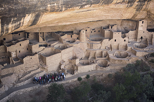
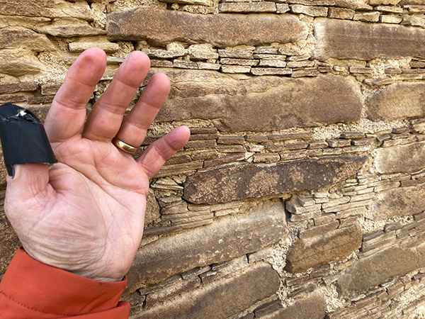
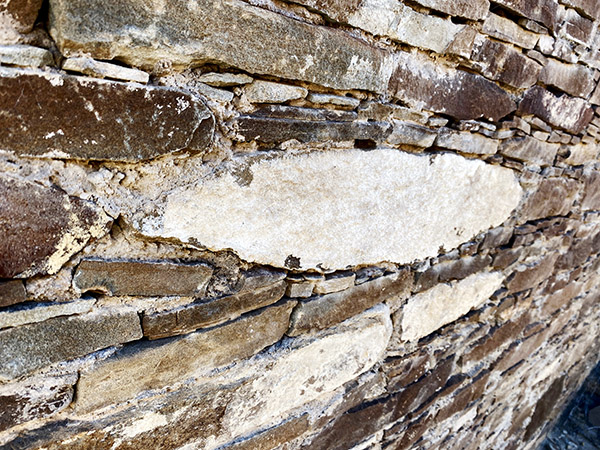
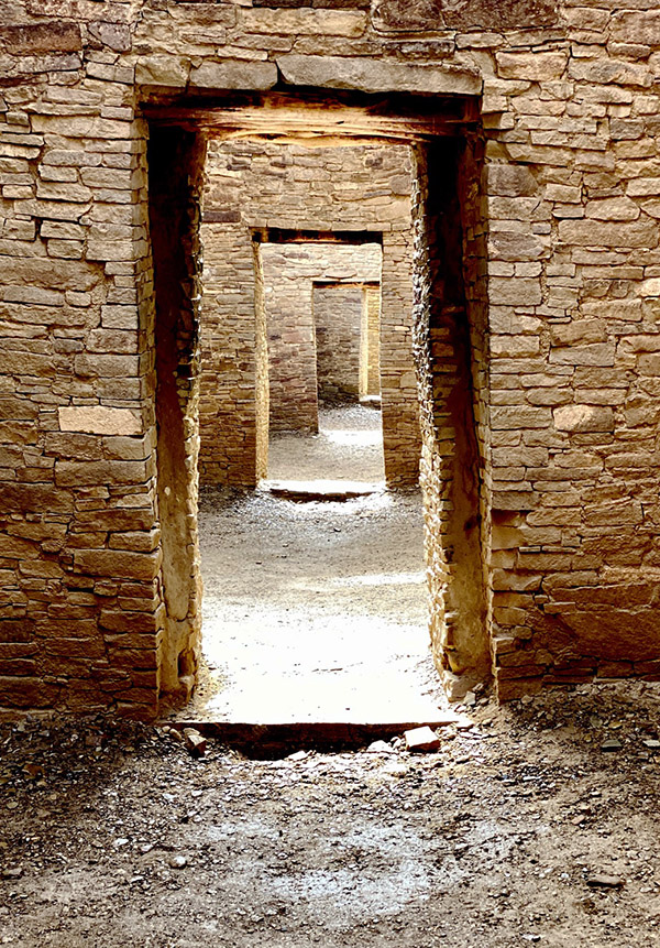
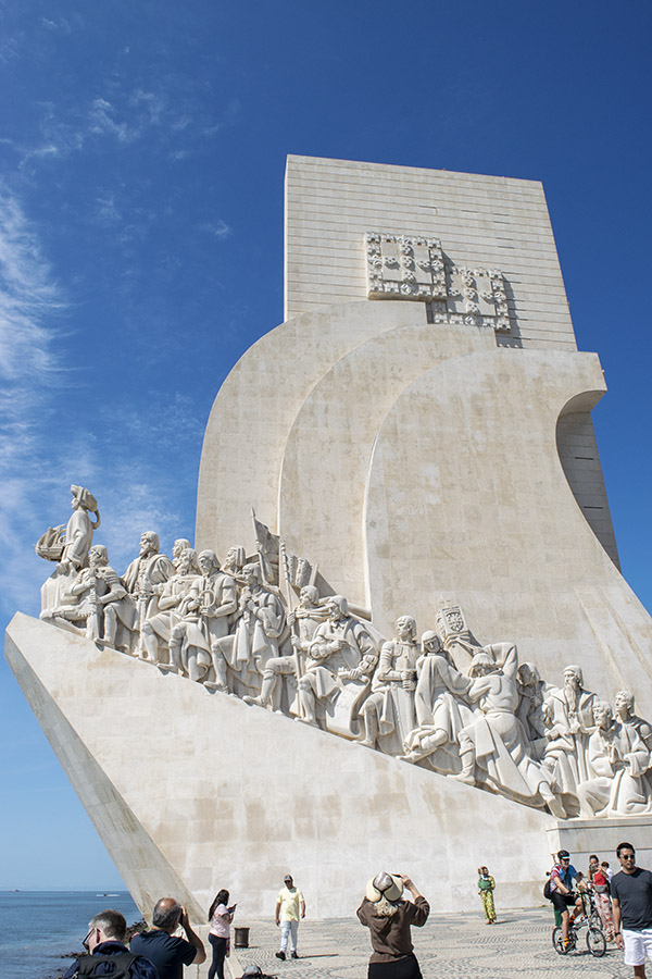
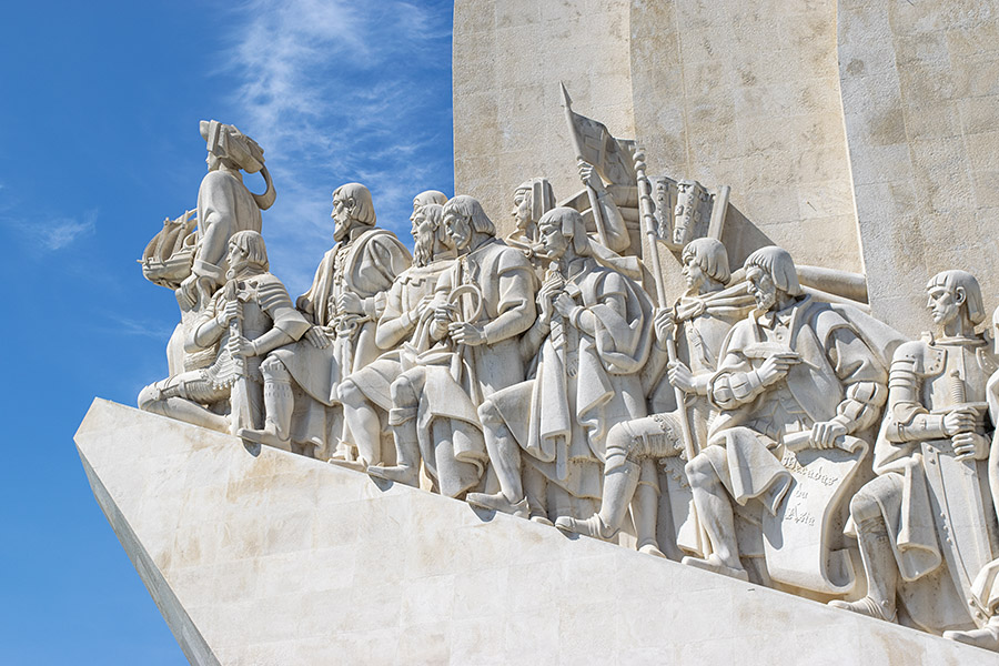
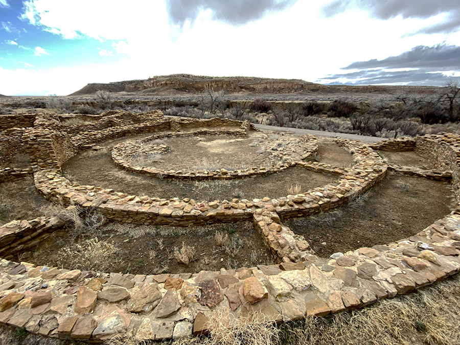
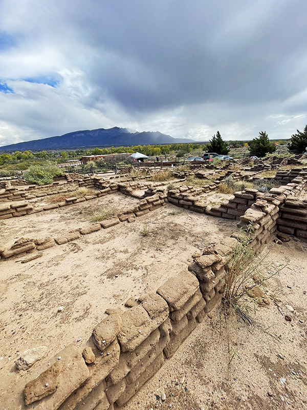
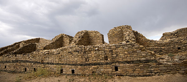
In 2019 we booked a campsite at Chaco Canyon in northern New Mexico. Chaco Canyon was a fairly large Native American city that served as the capital for the Chaco people a thousand years ago. Strung out along the canyon within walking distance of each other there are several large, condominium-style structures, some reaching 5 stories high and all of them with courtyards, living areas, kivas, and storage rooms. The condos were built with fantastically intricate stonework consisting of millions of large and small stones. Chaco society was well organized and their mathematics and architectural engineering were well advanced, as it would need to be in order to produce such big, complex buildings.

Also in 2019 the plague hit and Chaco Canyon was closed to visitors, so we never made it to the campground. The same thing happened in 2020, so we missed Chaco that year and instead spent our time arguing on the Internet about masks and vaccines with medically-trained basement dwellers. In 2021 we had a reserved campsite near the cliffs of the canyon and not long before we were due to arrive the cliff calved, covering our campsite with boulders. The campground was closed in order to clean up the rubble. The section where we were booked is still closed.

In 2022 we again called the ranger station at Chaco Canyon and reserved a site.  All looked well in 2022 but a day or two before we were to leave CT came down with a nasty cold and we decided camping would be no fun with one of us sick in bed. Reluctantly, we cancelled our reservations yet again. Our efforts to see Chaco Canyon seemed cursed. We decided to try again in 2023 and figured March would be a good time to go. We wanted to avoid the hot summer months. Building up to March everything was going swimmingly; this would be the year we finally made it to the historic Native American site.

And then the rain started. We watched the weather reports coming in from Chaco Canyon: rain, snow, hail. It rained at Chaco Canyon every day the week before we were to go. All roads leading to Chaco Canyon involve quite a few miles of dirt. The rougher, south entrance to the canyon was closed due to the muddy road being impassable. We didn’t care: we were going to Chaco even if we drowned in mud. Farmington was our staging area for the camping expedition and we drove in spotty rain all day to get there. Turning north out of Albuquerque on Highway 550 we stopped for gas. While I was filling the gas tank it started snowing. Then the wind picked up to a brisk gale. The last 50 miles to Farmington were in a drizzly rain mixed with sleet. We made it to our motel where it rained all night long. The normally well-maintained north entrance road to Chaco Canyon was starting to look a bit iffy.

The next day was overcast and rain threatened, but the morning was drama free with only a light dusting of snow on our way to the entrance to Chaco. If you’re going to visit Chaco Canyon you’ll no doubt read horror stories about how rough the road is leading to the canyon. Keep in mind the people fretting about the road are driving giant RVs held together with staples and chewing gum. You may lose a kitchen cabinet or an ill-considered propane tank. If you are driving a car or truck you’ll be fine. Unless it has rained five days straight before you arrived.

Turning off Highway 550, the first 8 miles to Chaco Canyon are paved and then the road turns into wide, graded dirt. This section was very muddy and CT put her Jeep in 4-wheel low and locked the front and rear differentials. She couldn’t go very fast because the Jeep wanted to spin into the ditch at the slightest sign of ham-fisted steering. Down hills were exciting; the Jeep kind of drifted to the bottom in a semi-controlled slide. The mud wasn’t deep, only a few inches, but it was like driving on ice covered with ball bearings and oil.

We saw two other vehicles on our 23-mile ride and one of them was stuck in a ditch. CT is a big believer in recovery gear so she has straps and chains onboard at all times. Unfortunately this means we have to stop and help people who get stuck in a mud bog. The guy was so glad to see us. We came to a gentle stop 30 feet past the deepest part of the mud hole. “You got a rope?” I asked Mr. Stucky.

“No I sure don’t,” he said. I gave a dejected look at the mud.

“Do you guys have anything we can use?” he asked.

“Yeah, we got something.” I stepped into the mud and pulled CT’s clean ARB tow strap out of its clean zipper case.

“I think if you can pull me back onto the road I’ll be ok. I was going too fast and spun out.”

I was only half listening to Stucky.  All I could think of was that this means we have to get CT’s ARB tow strap muddy with this sticky goo and then I’ll have to clean it later.

Walking was hard due to the mud sticking to our boots and the slipperiness, but we managed to connect our nice, clean, tow strap to Stucky’s SUV and pulled his rig backwards towards a less muddy area. Stucky’s mini SUV didn’t want to leave the ditch and it crabbed along spinning wheels and slinging mud for 100 feet before it popped out of the rut and onto what passed for the road. I started to wind up the tow strap when Stucky, sensing my disappointment, said, “Here, let me get that. No need for you to get any muddier.” I was muddy already, but I handed Stucky the strap. I wanted him to feel like he had a stake in not getting stuck again. As Stucky coiled the ARB tow strap mud oozed between each wrap. We were only a few miles to the campground from this point.

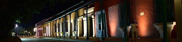
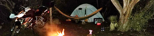
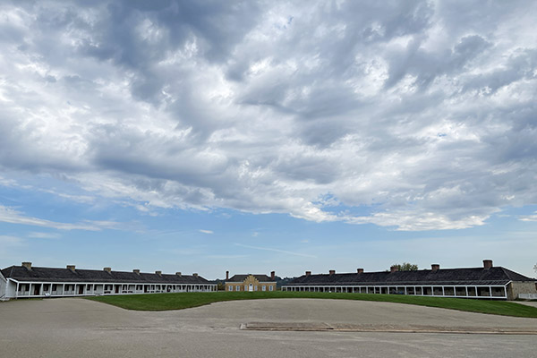
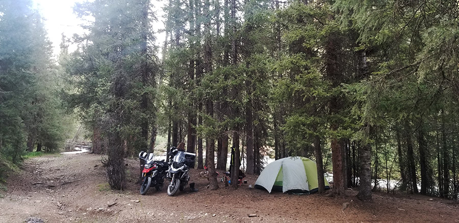
Once you make it to Chaco Canyon the roads are paved so we had no trouble finding the ranger station or our campsite. The place was nearly deserted. Stucky’s little teardrop trailer was the only other camper at Chaco that day. Fast moving clouds scudded from west to east bringing alternate periods of sunshine, snow, rain and hail. During a sunny spell we set our Campros tent up on the nice, raised tent platforms provided to each camping spot. The raised tent spots are built from pressure treated 8×8 beams laid out in a square totaling 14 feet by 14 feet. The squares were filled with nice, soft dirt and we were damn near glamping, you know? I guess if I were more observant, the tie down clevises screwed into the pressure treated lumber would have given me a hint about wind speeds in Chaco Canyon.

We watched the looping, 15-minute Chaco Canyon video at the ranger station’s little movie theater and then decided to set up and get our junk sorted out. It was windy and cold but we had plenty of warm clothing to wear. CT brought along 6 jackets, 7 hats, and 3 duffle bags full of thermal underwear. The tent was heaving and snapping; it took two people to hold it still long enough to assemble the thing. The temperature started dropping as soon as the sun went down. A campfire was out of the question in this wind so we made our bed, ate a little cold-cut snack for dinner, drank hot, Dancing Goats coffee and sat at opposite sides of the tent holding the corners down.

Moving all the heavy gear to the perimeter of the Campros tent seemed to keep it from blowing over. We were able to snuggle together in the sleeping bag and kept from freezing, which was the whole reason I wanted to go camping with CT in the first place. We saw 27 degrees that night and the wind never stopped blowing. The next day was slightly warmer and the sun was peeking out from the clouds, but it was even windier.

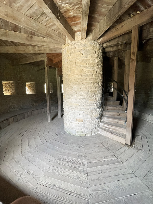
Due to the weather all the ranger presentations were cancelled. We signed up for a Chaco tour led by a Navajo business called Navajo Tours USA. We used these guys before at the Bisti Badlands and they are great fun. The tour started at 10 a.m. and we went to each condominium and wandered around while our guide told us about the different stone patterns and construction details of the buildings. Usually Chaco great houses have a basement level and many of the places we were walking had filled in with dust and sand over the preceding thousand years.

Above the basement there were three or four stories. Each level was accessed by a ladder from the level below. This system continued on until you reached the roof. The floors were made from large wood beams, called vigas in Spanish.  Over the beams were placed smaller sticks and an adobe floor. The vigas hauled to Chaco came from the mountains many miles away. I figure there must have been some sort of money or economy that would have allowed workers to drag those beams and still be able to sustain a living wage.

The walls of the condos were fairly thick. Starting at the bottom the walls were three feet thick or more. The walls tapered as they rose, becoming thinner floor-by-floor.  Top-floor walls might only be one foot thick. Originally, the inner walls were plastered smooth with some sort of lime coating. In a few spots you could still see the factory stucco. There were windows that let light into the rooms.  Inner rooms were dark but they had openings that aligned with outer windows that allowed outside light to penetrate several rooms deep. The outside windows had wooden shutters for winter use.

The winds, strong already, were picking up and at times you’d be blown off balance. Each gust brought a stinging blast of sand and my eyes were getting full of grit. The Chaco people situated their buildings according to astronomical events. Usually one long, straight wall aligned with the rising sun at the solstices. Sometimes the wall pointed towards a particular star. The building was a giant calendar.

There is a lot more to the Chaco culture, the long, straight roads they built, where their food came from, and why the city was abandoned after only a few hundred years, but it was late in the afternoon and getting colder. The wind was so strong I couldn’t hear our guide very well. Light hail was falling and wisps of snowflakes juked and stutter stepped in the air. As much as I enjoyed the lecture I was glad when it was over. I like it outside but there is such a thing as too much outdoors. We went back to the campsite to have a little hot tea.

Camp was a disaster. Our Campros tent looked like a downed weather balloon. Tent poles had broken, stakes were pulled out and the rain fly was detached and flapping in the breeze. Inside the tent everything was covered in dirt blown in through the screened roof.  We tried to get the tent propped back up but when I pulled on it things started ripping. We managed to get the rain fly back over the wreckage and placed large boulders on the corners to hold it in place. It was snowing again. There was nothing to be done with the wind blowing so we went to the ranger station and loitered. I bought a ceramic coffee cup with a Chao Canyon logo; it was good to be out of the wind.

By 7 p.m. the wind eased up a little and we went back to camp to try to salvage what we could. Our first chore was emptying the Jeep before it got dark. The idea being if we couldn’t fix the tent we could retreat to the Jeep and sleep in the back. Sure it would be cramped but at least we had a heater in the car. And the car wouldn’t blow over. Maybe.

We managed to get the tent propped back up with the short, broken poles. The short poles made every other dimension wrong. The main ridge pole had a huge S curve and there were wrinkles all over the place. It wasn’t a thing of beauty. Besides the broken poles, the upwind corners were ripped where the tent stake loops attach. We propped heavy stuff in those corners to hold the tent’s shape. Next we cleaned up all the sand as best we could and finally got organized enough to have another cold dinner and hot coffee. A campfire was out of the question because neither of us wanted to bother.  In retrospect, when we left that morning we should have lowered the tent and placed rocks on the rain fly to hold it down. I believe it would have survived without a problem. I have no gripe against the tent: it went through a hurricane.

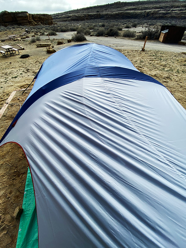
The jury-rigged tent stayed up all night long and by morning the sun was out and it was a relatively warm 40 degrees. Blue sky shined in through our open tent door and the wind was a gentle breeze. If our reservations were made just two days later we would have had a totally different feel for Chaco Canyon. It would have been nice Chaco Canyon instead of mean Chaco Canyon. The muddy road had dried up and was now passable by standard automobile. The campground started filling up as we packed our gear. Old Joe would have folded up the battered tent with the broken poles and torn corners, taken it home and stored it for 43 years thinking he was going to fix it one day. New Joe tossed it in the dumpster.

Those long-ago Chaco people had it much better in their thick stone buildings. Maybe the climate was different then, but I suspect not that much different. And it was an unusual weather pattern that saw all the other campers cancel their reservations leaving only Stucky, his dog and us in the entire joint.  The campgrounds were nice with clean bathrooms, flush toilets and heat, but no showers. We never did get to see all the buildings because it was so windy and cold. CT and I want to back to Chaco Canyon and explore more but maybe next time we’ll go when the weather is more clement.


Never miss an ExNotes blog:


You know what to do:  Please click on the popup ads!

Albuquerque Balloon Fiesta

By Joe Berk

The turnaround point for our New Mexico trip was the Albuquerque Balloon Fiesta.  We had talked about it for years, and it combined nicely with our stops in Tucson and Alamogordo (and the visit to Tinfiny Ranch).  I shot all the photos in this blog with my iPhone.  I had the big Nikon D810 and its boat anchor 24-120 lens with me, but my leg was acting up (an old motorcycle accident injury) and I couldn’t lug that thing around any longer on this trip.  I might have shot better photos with the Nikon, or I might not have shot any at all if I didn’t have my cell phone.  Adapt, improvise, overcome.

The deal on our visit to the Balloon Fiesta was a tour group.  It’s really the only practical way to get in to see the balloons.  Here’s the deal:  Albuquerque’s population is 550,000 people (it’s the biggest city in New Mexico).  The Balloon Fiesta, however, draws a cool one million visitors.  Just getting to the field where the balloons lift off would take an hour or more due to the crush, and if you did that, you’d have to park far away to find a parking spot.  If you’re part of a tour group, however, you ride on the tour group’s buses from your hotel to the balloon field, and they take you right up to the gate.  The City of Albuquerque has done this event for years and they have it dialed.  They designate special bus lanes during Balloon Fiesta week.   Logistically, it’s a much better approach.

What the City can’t control is the weather, and hot air balloons are sensitive to the weather.  If there are electrical storms, low visibility, rain, or high winds, the balloon’s won’t lift off.  And there were plenty of all these conditions that week.  Our tour grip told us we’d be making three trips to the balloon field, but there were no guarantees we’d get to see the balloons lift off during any of our visits.  Two of our visits were early morning affairs (we arrived at the field before sunup), and another one was in the late afternoon.

The Balloon Fiesta field periphery is lined with vendors.

During our first early morning arrival, it was cold and too windy for the balloons to lift off.   The balloon fiesta had a backup plan, though, and in the distant skie we observed a light display.  At first I thought there was a large board with lights, but then the display lifted into the pre-dawn sky.  I learned it was all down with multiple computer-controlled drones.  That was impressive.

Cell phone photography is like halitosis…it’s better than no breath at all. Each of these lights is carried by a single drone. They were probably a mile away when I took this photo.

The images changed.  We couldn’t see or hear the drones, and there was nothing from our location that would indicate they were drones.  It was impressive.

A Puebloe Native American symbol, commandeered as the image on the New Mexico flag. This is the area where we had breakfast. Breakfast was a part of the tour package.

During our second visit, which occurred in the afternoon, the wind conditions weren’t acceptable and there was a thunderstorm moving in, which prevented the balloons from ascending.  But it allowed a parachute display, and I grabbed a few photos of it.

Selection.com is a personnel agency.

Evidently the smoke generators the parachutists used create debris.  One particle hit me in the face.  Fortunately, it caught me in the cheek and not in my eye.  That would have made for an interesting lawsuit.

Another photo of the parachutists.

Even though it was too risky for the balloons to inflate and ascend, there was a lot going on.  It was fun walking around and taking iPhone pictures.

A fire truck at the Albuquerque Balloon Fiesta.

Our third and last visit to the balloon fiesta field was on a brisk Sunday morning and it was the charm.  After being skunked on two prior visits, the word was out:  The balloons had the okay to inflate and liftoff.  The winds were suitably low, visibility was good, and there were no looming electrical storms.  It was a go for a mass ascension, which kind of sounds like a religious experience.  In a way, it almost was.

Balloons inflating after recieving the go ahead. You walk in amongst the balloons. It’s all very exciting.

In a strange kind of way, being in the middle of the mass ascension kind of reminded me of seeing the whales in Baja. You go out in a small boat and for a while, nothing happens. Then you see a lone whale spout in the distance (like that one balloon you see going up in the photo above). Then, suddenly, there are whales spouting all around you, and then they are right up close to the boat. The balloon fiesta is a lot like that. Nothing happens at first, then you get very excited when you see that single first balloon ascend. Then, suddenly, balloons are going up all around you.

Our first balloon going up.
Then, suddenly, there are balloons everywhere.
The cell phone was doing a decent job for me. I would have liked having the D810 with me, but it was not meant to be. Maybe next time.
The colors, and the vibrance, was off the charts. The balloon fiesta is a photographer’s paradise.
Approximately 650 balloons ascended within about 30 minutes. It was impressive.
Several of the balloons were more complex shapes, like this Felix the Cat version. There were turkeys and other shapes as well.
This last photo is a panoramic shot, in which you manually sweep the camera through an arc (in this case, about 180 degrees). The iPhone does a suprisingly good job. The actual image is a little over 16,000 pixels wide.

A question several of my friends asked is:  Did we go up in a balloon?  The answer to that is no.  You have to make a reservation far in advance to get a seat in one of the balloons (we had not), it costs several hundred dollars, and truth be told, I wasn’t too sure about doing it.  Joe Gresh, whom we visited on our trek to Albuquerque, had done it in the past and he told us he and Colleen enjoyed it.  Maybe next time.

If you have any thoughts about visiting the Albuquerque Balloon Fiesta, my advice is to go for it, and to do it through a tour agency for the reasons listed above.  It’s a bucket list sort of thing to do.   We went with the Road Scholars tour group, they did a great job for us, and they kept us busy for the three days we were in Albuquerque.


Please keep clicking on those popup ads…it’s what keeps the lights on!


Never miss an ExNotes blog:

A Sneak Preview…

Wowee, do we ever have some good stuff coming up right here on the ExNotes blog.  Guns, motorcycles, adventure touring in Transylvania, and the results of a content safari through Arizona all the way to Albuquerque.  Here’s an inkling of just a few of the topics coming your way.

What’s the real difference between a $1500 Colt Python and a $650 Ruger Blackhawk?   Watch for our side-by-side, target-by-target comparo.  It’s coming up.

Into resurrections?   Hey, how about CSC’s replica of the original Mustang motorcycle!  You read our recent story about the Al Simmons Mustang motorcycle collection and the origins of the Mustang.   CSC’s Steve Seidner went a step further, and we’ll tell you all about it.

Ever have your well dry?  I mean literally, not figuratively.   Uncle Joe Gresh has, and he’ll tell you all about it.  Gresh is a guy who makes MacGuyver look like an amateur.   You’ll love this story.

We’re going to bring in a new writer or two (or maybe more).  We have a blog loaded and ready to publish from good buddy Airborne Mike on a motorcycle ride through (get this!) Transylvania!  I kid you not.  Transylvania and the Transfagarasan Highway!

On that topic of new writers…Joe Gresh will tell you all about what you need to do to be considered for the ExNotes editorial staff.  Watch for a blog on this topic in the near future.

The Pima Air Museum in Tucson is another treasure.  Wow, that was a fun visit.  There’s so much there we couldn’t take it all in during a single visit, and it’s a place that screams for more than a single blog.  I need to return.  The photo ops were incredible.

More good Joe Gresh stuff straight from Tinfiny Ranch, including the Gresh moto stable and the world famous Gresh project bank.  Motorcycles, the MGB-GT, and more!

How about the Franklin Automobile Museum in Tucson, Arizona?  Never heard of it?  We hadn’t, either, but (trust me on this) it’s Tucson’s best kept secret!

White Sands Missile Range?  Yep, that, too.  Everything from a Nazi V-2 to current US weaponry, and we’ll have the story right here.

How about White Sands National Park?   Think Sahara Desert, and you’ll have a good idea about what these rolling snow white gypsum hills look like.  It was awesome!

The New Mexico Museum of Space History, with a guided tour by none other than Joe Gresh?  That was a really fun visit with lots of cool exhibits.  It’s coming your way.

How about sacred Native American ruins in New Mexico?  We saw several and they were impressive, including the Kuaua Native American site along the Rio Grande River.

Albuquerque is quite a town, and Old Town Albuquerque is quite the place.  We had a lot of fun wandering around and taking photos.  It’s in the mix for a future blog.

And the Albuquerque 50th Anniversary Balloon Fiesta…wow, was that ever spectacular.  The excitement and wonder of that event is one of the most impressive things I’ve ever experienced.

Stay tuned, folks.   It’s quite an adventure, and it’s onging!


Click on those popup ads…we get paid everytime you do!


Never miss an ExNotes blog:

Aztec Ruins, New Mexico and Motorcycle Classics magazine

This was exciting…Susie and I were tooling through New Mexico on  our way to Mesa Verde in Colorado when we spotted a sign for Aztec Ruins National Monument.   We’d never been there.  In fact, we had never even heard of the place.  But it’s there, it’s real, and it’s a grand destination.  The result?   Well, hey, check this out!

Empire of the Summer Moon

When I’m on a road trip, I sometimes know the history of the area I’m riding through, and I sometimes do not.  I’m always wondering about it, though.  I recently finished reading Empire of the Summer Moon, and it was so good it makes me want to plan another road trip through Texas.  The cover tells what the book is about; what it doesn’t do is tell just how good this book is…

Several things amazed me as I read Empire of the Summer Moon, the first being how it could have not known of it previously.   The only reason I learned of it is that I saw Empire in an airport bookstore a couple of trips ago.

They say you can’t tell a book by its cover, but the cover on Empire appealed to me greatly.  The book was even better.  Much of the action described in it occurred in Texas (and in areas where I used to live in Texas); now I want to return, ride those roads again, and pay more attention this time.  And I will.  Just how good was this book?  Hey, when I finished it, I turned back to the beginning and started reading it again.  That’s good.

Header images: An update!

Yep, we’ve added a few new header images at the top of our blog again.   Every once in a while we like to add a few more, and on occasion we’ll blog about what they are.  Every time you visit the blog, one of a dozen or so images randomly pops up at the top of our blog.   If you’ve wondered what they are, today is the day your ship comes in!  Here’s a brief explanation of each…

This is the original ExNotes blog header image, which will still pop up from time to time. I love this photo. I took it on the ride through Colombia in Mompox, a mystical town tucked away in a magic land. I’d like to invite you to read the blog I wrote on Mompox a few months ago. If you look real close, you’ll see my good buddy Juan, who I rode with in Colombia and on the CSC Western American Adventure Ride.
Ah, the whales Scammon’s Lagoon, Guerrero Negro, Baja California Sur. Gresh and I are going to ride there in March. It’s one of life’s real treats. We’ll be blogging the entire trip, and we’ll be insured with BajaBound Insurance (the best there is).
Wow, another Guerrero Negro photo, this time after the bikes had been put away for the evening at the Don Gus Hotel. I love the hotel and the restaurant (and the bar, too!) at the Don Gus Hotel. This was on one of the CSC Motorcycles Baja adventure rides.
One of the best parts of any Baja adventure ride is the cuisine. These are tacos we enjoyed on the recent ride with Janus Motorcycles. The food down there is fantastic!
Janus Motorcycles parked along the Malecon in San Felipe. This was a great Baja ride, and the Janus machines performed perfectly. It was a grand adventure. Hell, they all are!
A photo of Jordan Swartzendruber (on the left, hugging the center line) and Devin Biek (on the right), both on Janus Motorcycles. We did about a thousand miles in 4 days on these 250cc motorcycles. It was one of the coldest rides I’ve ever done, but we had a grand time!
Ah, my old Daytona 1200 on the road near Shiprock, New Mexico. I grabbed this photo during the 2005 Three Flags Classic Rally, in which good buddy Marty and I rode 5,000 miles from Mexico through the US and on into Canada. It was a grand adventure!
This is another photo from the 2005 Three Flags Classic, somewhere on the road in Arizona. There were over 400 motorcycles in the ’05 TFC; I rode the only Triumph in that event!
A lot of folks get their shorts in a knot when they see this photo. It’s Elmer, my good buddy and mature Mexican rattlesnake catching some rays and staying warm.  We were on the road to see the Sierra San Francisco cave paintings in Baja. Elmer was very cooperative that morning, and I got some fantastic photos of him.
Good buddy Mike Huber shot this photo of his campsite and he graciously allowed us to use it on the ExNotes blog. Mike wrote a guest blog for us on using hammocks. Mike lives on his motorcycle, camping wherever he finds a good spot.  What a life!
At Zongshen plant in Chongqing, China. We were moments away from starting our motorcycle ride across China, and the Zongers had a departure ceremony for us. That was one of the greatest rides I’ve ever been on, and you can read all about it Riding China. Gresh rode that one, too, and you can read his story about the trip here!
The lighthouse in Baja’s Guerrero Negro. It’s where we go to see the whales. This is an interesting photo…it’s a composite stitched together from six photos shot from left to right. I had a polarizer on the camera, which explains why the sky is darker in some portions of this composite.

Good times, to be sure.  We’ll be adding more photos in the future, so stay tuned.  Keep coming back to the ExNotes blog and you’ll see a different header time each time you visit!

Mesa Verde in Motorcycle Classics

Native American cliff dwellings in Mesa Verde National Park.

The latest Motorcycle Classics has a cool article on Mesa Verde National Park in southwestern Colorado.   Sue and I were there last year and it’s definitely worth a visit if you’re in the area.   Nah, let me change that last sentence: Mesa Verde National Park is worth a visit all by itself, wherever you are.  It’s only an 11-hour ride from Los Angeles on the freeways, although if I were going there again it wouldn’t be a freeway ride.  There are just too many interesting things to see on the our secondary roads. I’ve been writing for Motorcycle Classics for about a decade now, and you can see more of the MC articles here.

Three Flags Classic: Day 2

The second day of the 2005 Three Flags Classic motorcycle rally would take us from Gallup, New Mexico (where we stayed the first night of the tour) to Grand Junction, Colorado.  You can catch up on the ride by reading our prior blog posts here:

The 2005 Three Flags Classic Rally:  the Intro!

The Three Flags Classic:  Day 1

And with that, let’s get to Day 2!

Day 2 of the 2005 Three Flags Rally. Good times. Great roads. Gorgeous scenery. A grand ride in every respect!

To continue the adventure, we were up early and we rolled out of Gallup, New Mexico on a beautiful day.  The bikes were running great and Marty and I were in high spirits.  It’s hard to put into words what it feels like to be on these kinds of rides.  You’re out in the world, on a powerful motorcycle, seeing things worth seeing.   It’s a great experience and a great feeling.  Everything just seems better to me when I’m on a motorcycle ride.  I sleep better, the food has better flavors, the people are friendlier, the bikes feel stronger, and on and on it goes.  You need to experience it to really understand it.  You folks who ride the big rides know what I’m talking about.

We spent very little time on the freeways on the Three Flags Rally. Most of our riding was on magnificent roads like the ones you see in the photos below.  The folks at the Southern California Motorcycle Association who planned the ride did a fantastic job.

Another cool shot on the road in New Mexico. That’s Marty and his K1200RS BMW, with my Daytona in the background. Marty still owns the K1200RS. It has 144,000 miles on the clock.
Another Daytona shot in New Mexico. That’s Shiprock in the background.

If it seems like there are a lot of pictures of my Daytona here, well, I guess there are. I loved owning the Daytona, and the more I rode it, the more I liked it. For a cool story on how I came to own this bike, check out this blog entry I wrote a few months ago.

A few miles up the road from this location, we crossed into Colorado. This was my first time in Colorado, other than passing through the airport in Denver a few time on business trips.  But those stops don’t really count…a layover in any airport could be a layover in, well, any other airport.

Mesa Verde, Colorado. Wow…this was a great ride!

Marty wanted to stop in Mesa Verde National Park in Colorado.  I had never heard of the place (I don’t get out enough, I guess), but I was up for it.  Marty was a very easy guy to travel with and he didn’t have many preferences.  He was a judge (that is to say, he’s the real deal…a Superior Court judge), and he told me that he didn’t want to make any decisions on this ride.  Where we stayed, where we stopped to eat, and all the rest were up to me.  I think that’s because Marty was paid to make decisions all day long.   Making decisions was his job, and he wanted a break.    So when he asked to hit Mesa Verde, it was about the only time he expressed a preference on where to go, and I was all for that.  It was a good move.   Mesa Verde National Park is an impressive place.

The ride up to the top of Mesa Verde (it literally means “green table” in Spanish) was awesome.  It’s a multi-mile climb to about 8500 feet, and the vistas are incredible.  You can see clear into New Mexico from the top.

All of the above, as you can see from the photos, was grand.  But the main attractions at Mesa Verde National Park are the ancestral Pueblo Native American ruins.   That part of the Park is almost beyond belief.  It’s real Indiana Jones stuff.

Ancient Indian cliff dwellings in Mesa Verde. If you’ve never been to Mesa Verde National Park, trust me on this: You need to make the trip. Watch for the next issue of Motorcycle Classics magazine…it’s got all the good info on where to stay, where to eat, and more.

Mesa Verde is a very interesting National Park.   I liked it so much that Sue and I took a road trip there last summer to explore the area in more detail.  I’d been thinking about it in the 14 years that have elapsed since the 2005 Three Flags Classic.  I wanted to see it again and bring my wife so she could see it.   The Native American cliff dwellings are amazing and the scenery is magnificent.  I have a story coming out on Mesa Verde in the next issue of Motorcycle Classics magazine.  It really is a special place.  Marty made the right call on this one.   Hey, he’s a judge.  The guy makes good decisions!

After Mesa Verde, we rode through heavy rains along the Dolores River and stopped in Telluride, Colorado.  The sun came out just as we entered town.   The ride along the Dolores River in Colorado was beautiful even in the rain.   We were having a grand time.

Downtown Telluride, washed clean by a torrential Colorado rain.

We had a checkpoint in Rangely, Colorado. It was a great experience.  I had a conversation with a guy named Pat (a BMW GS rider), and it turned out he lives one street over from where I live in California.   I mean, think about that: Here we were, probably 1300 miles from So Cal, two guys strike up a conversation, and it turns out we’re practically neighbors (but we had never met before this ride).   What are the odds?

Good buddy and GS rider Pat, a fellow Californio, at a checkpoint in Colorado.

We made Grand Junction, Colorado, where we would be spending the night, and we reconnected with our friends at the hotel.  Dinner was great, and then the rain started again.   I felt like taking more photos after dinner and I wanted to play with a couple of new toys.  I had just purchased an ultra-wide Sigma 17-35 lens and I wanted use it.  I had also purchased a Sunpak MiniPro Plus tripod for the trip.  It looked like it was going to be a good idea, but it was a bust. One of the legs broke off halfway through the ride, and I threw the thing away.  I almost never travel with a tripod any more.   They’re just too bulky, and I can usually find something to steady the camera for evening shots.

Our bikes, parked in the rain at the hotel in Grand Junction, Colorado. I used the 17-35 Sigma for this shot, and my uber-cheap tripod (before it broke).

That wrapped up Day 2 of our Three Flags Classic ride in 2005.   It was a great ride.   We were two days into it and we had already ridden halfway across the United States.   Out tally so far was two countries and four states.  We still had several more states and another whole country to go.  It was magnificent.

There’s more to come on this grand adventure, folks.  Stay tuned for Day 3!